2. Lest we Forget - The Shotover Claim that started the Thames Goldrush
Richard (Dick) Wilkins
Note to Reader: This article is very comprehensive, aiming to be a “document of record” for serious researchers to use as a resource. The casual reader may only wish to delve into the Introduction, skim over the photographs and look at the maps in Appendix 1. If they are interested in the life of William Hunt, Appendix 2 constitutes the most comprehensive account that has been published.
The unit of currency - the British Pound (£1) converts to approximately NZ$200 in today’s currency – another yardstick that gives a reasonable idea of its value is that most men in in labouring jobs in 1870 were paid by the day; if they were employed for a full week, they would earn £3-5. There were no unemployment benefits and no insurance for the common man. The unit of weight was the Imperial Ton which is close to 1000kg. Hand trucks pushed on rails held approximately 11/2 tons but hundred-weights (cwts) – 1/20th ton were a more practical measure for what was carried in wheelbarrows or sacks. Tunnels and shafts were measured in feet (~0.3m) and the depth of a shaft was measured either from the “brace” at the top of the shaft, or variations on feet above and below sea level which sometimes caused confusion.
Introduction
Despite being the paramount historic site on the Thames Goldfield, the Shotover Claim languishes as a completely unmarked piece of land covered in scrappy bush that is visited by few people. The only clue to its location is a vague sign entitled “Shotover Mine” at the edge of State Highway 25 on the Northern outskirts of Thames, but even this does not inform the viewer that the site itself is just an easy five-minute walk up the Kuranui valley (Figure 1).
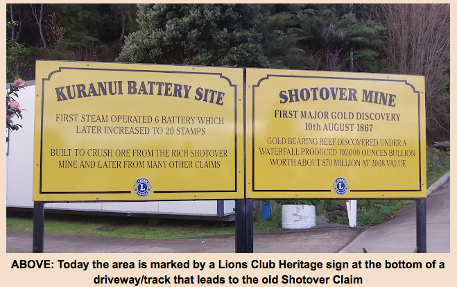
Figure 1. The Lions erected similar signs throughout Thames at historic sites (Image from Thames NZ: Genealogy and History Resources: Althea Barker)
The neglect of this site is puzzling, given the pride Thames places on its gold-mining history. Part of the reason might be the tendency to look back on the discovery of gold in Thames through rose tinted glasses, with many accounts waxing on in general terms about mines and claims, and the untold riches that flowed and, in turn, supported Auckland through a time of depression. The Shotover Claim is often just a footnote to all of this.
In fact, the proclamation of the Thames Goldfield on July the 30th 1867 was a bit of a gamble. There was no compelling geological evidence for it yielding other than the same modest gold returns other areas in the Hauraki district had given and were to give. However, Auckland was in a serious slump and a new goldfield at its doorstep might just solve some of its problems. The first week on the new goldfield was disappointing with only a few traces gold being found in alluvial deposits and minor veins; so much so that by the 8th or 9th of August, the field was being declared “a duffer” at a meeting of indignant miners (1).
All this changed dramatically when Hunt and party discovered an unbelievably rich gold reef. They had already pegged out the Shotover Claim on the 10th of August and when this news got out it started a Goldrush, an exodus from Auckland to Thames. A period of intense prospecting followed, with thousands of claims registered and the development of a mining industry which sustained Thames for many years. One can only speculate on how the Thames Goldfield would have developed if the Shotover bonanza did not exist. Probably the number of miners in Thames would have only numbered a few hundred, at most a thousand or so, and the development of the gold field on an industrial scale would have been much slower with deep level mining to uncover rich gold deposits being a much more measured capital-intensive activity.
So, what do we know about the actual site of the Shotover Claim that started off the Goldrush? Actually, these days, surprisingly little, apart from the fact it was the only bonanza above ground and that it demarcated the northern limits of highly profitable mining on the Goldfield.
In retrospect, I should know quite a lot, but until I researched the claim, I was as ignorant as most other people. As a boy, in the 1950s and 60s, I walked up the track past the old claim site hundreds of times when I visited the Ross homestead at the top of the valley. Our family rarely talked about the Shotover, even though my great aunt, Sarah Ross still lived in a large house overlooking the claim. The valley below her house was overgrown, full of mullock and virtually impenetrable except for a narrow track that gave access to the house itself. Various adits were visible and we were warned about the deep depressions that covered old shafts. The local population made use of these old shafts to dump their rubbish (as we did) and further up the valley flying foxes were installed from time to time to bring out firewood. There were even kennels where pig hunters kept their dogs.
By then, absolutely no evidence remained of the famed Shotover Claim and I now realise the simple reason for this was that the 30-foot waterfall and reef containing the bonanza, plus the valley floor behind it had been completely excavated by the late 1800s. Unless you knew this, one would automatically assume the track, as it exists today (in the region shown in Figure 14) was over original terrain.
Because the site has been completely excavated, it would be challenging to install any visitor information on site that would give a comprehensive picture of the Shotover Claim as it existed around 1870.
A solution to this problem, in my view, would be to construct a 3D model(s) of the 1870 site to be mounted in visitor destinations in the town itself. The technology using 3D printing coupled with LIDAR files (see Figure 4) is now quite sophisticated and constructing models such as the example shown below is reasonably straightforward. The beauty of this approach is that, as well as giving visitors a very good understanding of the premier historic site in Thames, it could be coupled with directions on how to access the site. It is an easy 5min walk from the main road and better signage (both on the main road and on-site) would give anyone who had seen the model an immediate appreciation of what the Shotover Claim was like.

Example of a 3D Topology Model of 6 x 4 feet on a 30-inch Shadow Box
A somewhat more ambitious undertaking would be to design a historic round trip up Moanataiari Creek Rd, across the top of Kuranui Hill to the site of the old Eureka Settlement, then down the Kuranui – Eureka Track past the Shotover claim and back along Tararu Rd. This has been suggested by both Dave Wilton and Russell Skeet, who have organised guided tours along this route (see, for example the group in Figure 14). Logistically, this is perfectly feasible because the Thames Mountain Bike Club have gone to a lot of effort to cut and form tracks throughout this area, and they have already erected a comprehensive map at the Moanataiari entrance to the track. By foot, a moderately fit person can do the round trip in about 11/2 hours. Until now, the group leaders have played a key role in pointing out historic features, as almost all evidence of mining is hidden under rampant regrowth. To set up a self-guided trip, some kind of signage would be necessary and perhaps the best way of doing this would be via QR codes linked to historical details placed along the track.
The Shotover Site Before Mining
Putting together an accurate description of the site, as it exists today, and where various structures were located is not easy, but here I will summarise my research.
In 1869 the Kuranui valley catchment, which only extends a few kilometres into the ranges, supplied a stream that was little more than a brook except during heavy rainfall. The original mouth was onto mudflats, but this area has been radically altered, first by the extensive reclamation of the Moanataiari flat, then by the more recent development of Kuranui Bay reserve. I use the word “was” to describe the stream, as it seems to have disappeared completely in recent times, presumably due to a combination of water retention by the rampant regrowth and redirected flow into mine works. Not that it was ever a strong flow and no more than a couple of sluiceheads (2 cubic feet or about 56 litres a second) except after heavy rain. Lack of water was a major problem for miners in the valley.
We are extremely fortunate to have several images of this area taken in mid-August 1867 before mining started. These were taken by R.H. Bartlett, an accomplished Auckland Photographer (2). In Figure 2, looking north, we can see the mouth of the Kuranui Stream, as it flows across an area of flat no more than 100 metres wide with a track from Thames crossing it, leading to Tararu in the distance.
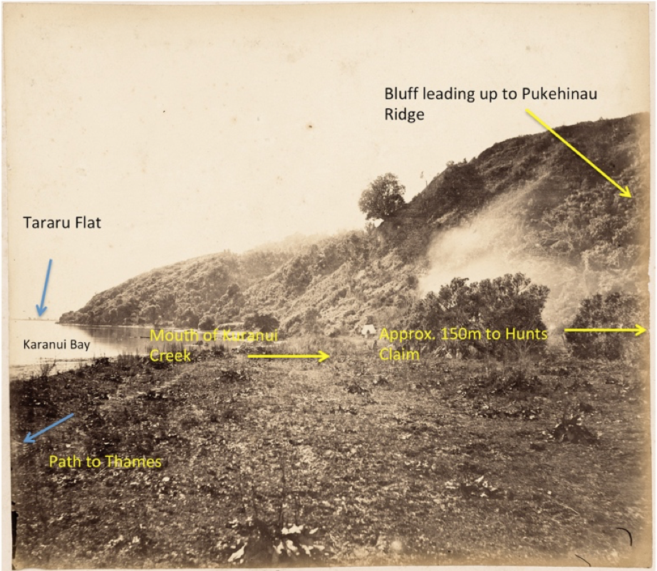
Figure 2. Photograph taken by R.H. Bartlett in mid-August 1867 from the below Long Drive looking North (2)
Another uncaptioned Bartlett image (Figure 3) appears to be taken from a high vantage point near the Long Drive Claim, looking south, showing the Thames flat proper with no signs of occupation, and only a few tracks through low bush, one of which leads north. Within a year, this flat was Grahamstown and a hive of mining activity.

Figure 3 A photo taken by R.H. Bartlett in mid-August 1867 looking South across the Thames Flat (3)
Kumara beds were cultivated by the Maori at the mouth of the stream, and there were persistent reports of alluvial gold being found in the stream bed but apparently they did not regard it as valuable. Of course, miners thought otherwise and realised the upper reaches of the Kuranui stream were prime for prospecting but, as is well documented, the centre of the stream bed defined the strict northern limit of the Goldfield that James MacKay had negotiated with Maori.
Clarkson is believed to have confirmed there was alluvial gold in the stream about the 8th of August. The sequence of events after that is a little confusing but Meghan Hawkes in her series “First Year on the Thames Goldfield” (4) summarises them as well as anyone. It appears that the next day (the 9th) Clarkson went back with Hunt as a mate, and they confirmed that the stream was rich in alluvial gold. The following day, they picked up White as another mate, went back to the Kuranui stream very early and proceeded up through the undergrowth with the tacit approval of at least some Maori. They soon came to an overgrown cliff extending across the whole valley with a small waterfall running over it; this is where Clarkson’s pick uncovered the rich gold reef. Back in Thames, they picked up a fourth mate, Cobley, and took out Miners Rights numbers 6 to 9 with Commissioner MacKay who then accompanied them back to the reef and allowed them to peg out 6 mens ground. Delicate negotiations with Maori allowed the field to extend north to encompass all of the Kuranui valley by the 12th of August.
Because of the huge changes wreaked by mining, it is now difficult to visualise what this area would have been like prior to August 1867 but some clues can be gathered by reference to recent LIDAR surveys of the area (Appendix 1). Careful examination of a 3D depiction from the LIDAR data shows evidence of the extensive mine workings around the Kuranui area (Figure 4a). Some idea of what it would have been like before mining can be obtained by “modifying” this image to show the approximate original ground contours.. The major feature that has disappeared in the Kuranui valley is the cliff and waterfall across the Kuranui stream where the Shotover Claim was located (Figure 4b). (Obviously, the foreshore has been extensively reclaimed as originally there was only a narrow strip of land running between the high tide mark and the hills).
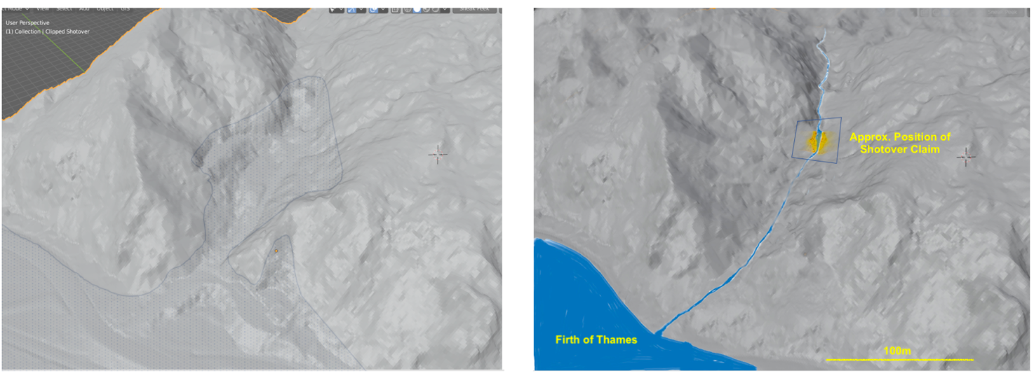
Figure 4 3-D images of the lower Kuranui Valley constructed from LIDAR data. The image (a) on the left is the ground topology as it exists today with the areas modified by extensive mining and reclamation outlined in faint blue (the distinctive flat area on the left of the valley is a recent excavation for a building site). On the right, in image (b) the valley has been “tweaked” to approximately its original shape with the Shotover reef and claim outlined.
We know from contemporary accounts that when Hunt’s party reached the waterfall, they clambered up both sides of it through heavy undergrowth. The total height of the cliff across the valley was at least 30 feet with the waterfall itself about 20 ft high. How do we know this for certain? Bartlett went up to the site late in the week of the 12th of August and took two photographs. Of these, “Hunt’s Claim No1” is the most informative, (figure 5).
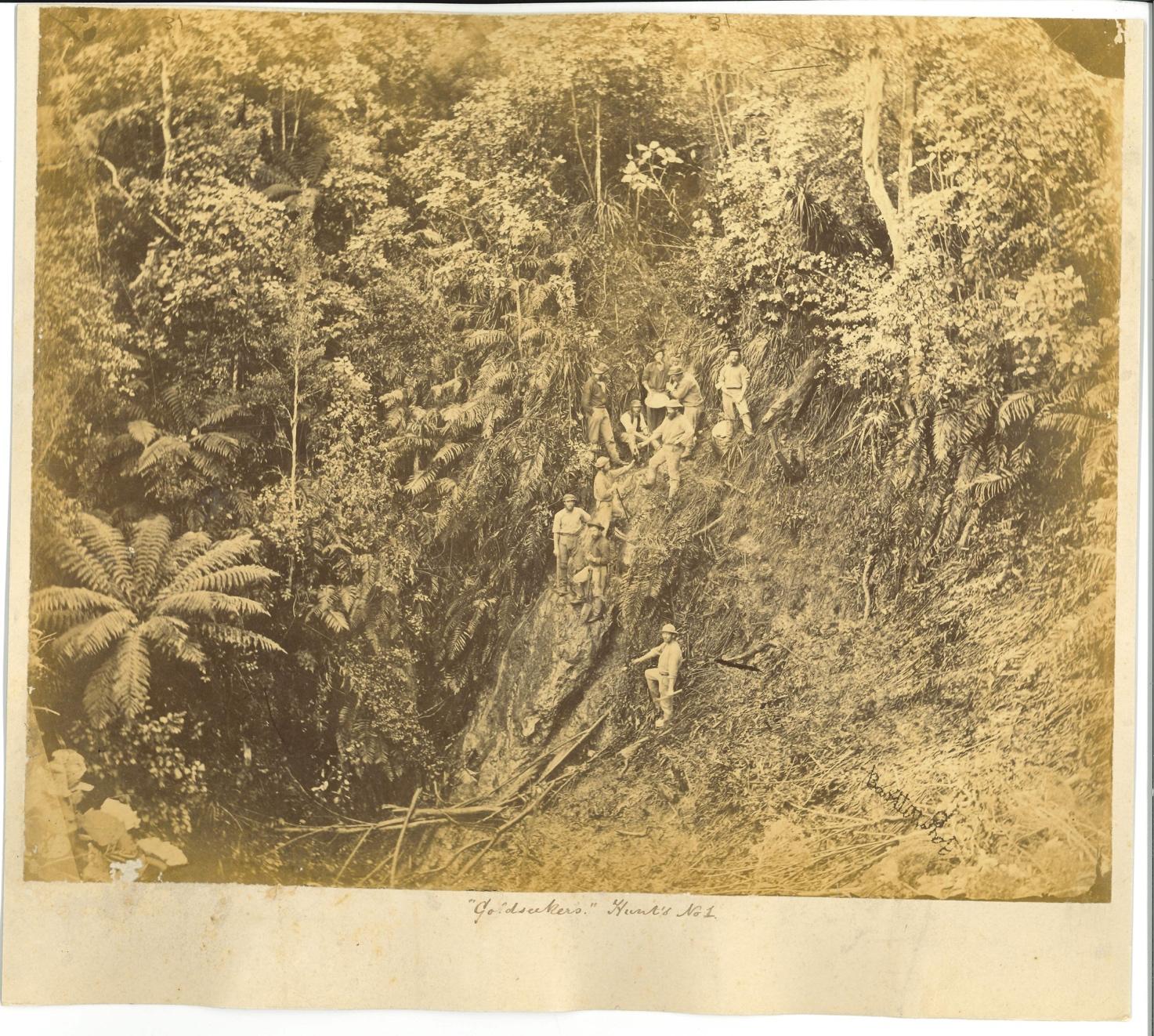
Figure 5. “Goldseekers” Hunt’s No1 taken by R.H. Bartlett in mid-August 1867 (scan of uncatalogued original print supplied by Keith Giles, Auckland Public Libraries, March 2022). (5)
At this early stage, the growth on the left-hand side of the waterfall is still untouched and gives a very clear indication of what was originally across the whole valley. Hunt’s party had not started mining proper and were concentrating on clearing growth and dirt from the right side of the waterfall; most of the people in this photograph are probably working on the face. The reef under the waterfall (immediately to the left of the group) and the vertical veins running up it are clearly visible. An accompanying photograph, “Hunt’s No.2” includes “some of the local celebrities” to quote the Daily Southern Cross reporter (6). It is believed that John White, “J.E.s” cousin, who was living in Thames at the time, is also in this photograph.
The area they pegged out for the Shotover Claim was centred on this waterfall and ran approximately 280 ft across the valley and 300ft up it, covering near to 2 acres (6 mens ground). Soon as the news broke, there was a rush to the area and claims were pegged out all around it. The most profitable of these were Long Drive to the south, with Barrys (soon to be the Kuranui) and then Deep Lead above it, these of a similar size and also straddling the valley. Miners had high hopes from claims to the North, such as Mt Eden, Golden Point and Golden Fleece but none of these were really profitable. The early miner’s peggings were inaccurate and after some juggling, debate and proper surveying, the boundaries of all of these claims were fine tuned. In its final form, the area of the Shotover Claim at 1acre 3 perches and 26 roods was slightly under 2 acres. (Figure 6). (Care has to be taken when viewing some maps redrawn by historians as they have confused the surveyor’s unit of the link with the foot. Also, indistinct numbers are often mis-transcribed).

Figure 6. The Shotover Claim. This is part of a much larger plan prepared for the Shotover Gold Mining Lease in April 1869; by this time, much more infrastructure is on and around the claim. Red numbers are distances in links and blue numbers bearings. (Serious mapping errors have occurred in other parts of this map.) (Scan supplied by Tom Barker. Plan held in Archives NZ)
Gold Extraction from the Shotover Claim
Some writers have pointed out that it is a bit of a misnomer to talk of the Shotover as a “Mine” - it was more accurately described as a Gold Quarry. The reason for this is very simple; the stupendous amount of gold Hunt’s party recovered from the claim was largely obtained by simply excavating the cliff face in the vicinity of the waterfall. Some of the techniques they used were very crude. For example, a battering ram was set up to smash the cliff face for pulverising in a berdan set up on the site. Despite this crude approach, they could tolerate the inefficiencies because of the extreme richness of the quartz. Just how rich the fragments of rock were can be gauged by the fact that just one good specimen could equate to a small fortune. Hunt patrolled the area, keeping out trespassers and even employing a private detective (who was exposed as corrupt). At one stage, they even erected a fence around the claim. It was said that quite a crowd used to come and watch proceedings from the surrounding slopes, which formed a natural amphitheatre.
In the first few months, ore appeared to be crushed on the site in a berdan that could only handle 1cwt per day (7). By November 1867 Fraser and Tinne had set up a small 6 stamper battery at the mouth of the Kuranui stream and occasionally Shotover ore was sent down for crushing. Tramways and chutes were also put in over the northern side of the Shotover claim to take Barry ore down to the foreshore battery. At about this time, a dispute arose over the transfer of Barry’s Claim to a Kuranui Gold Mining Company, and Captain Butt, William Rowe, C.J. Stone and others were involved in a messy court case which was finally resolved around March 1868 with the Kuranui company now owning claims above and below the Shotover Claim and taking over Fraser and Tinnes battery. Obviously, all of this was unsatisfactory for Hunt and it would appear they decided that a lot of their ore had to be processed on site.
Despite these limitations, a very significant portion of the reef had been excavated during this period, the extent of which can be gauged in photographs that Bartlett apparently took around December 1867. Unfortunately, none of the actual processing equipment is visible in these photographs (See Figure 7). By this stage, excavation of the cliff was well advanced particularly on the right side where rich quartz was found out to about 18ft) with the left side relatively untouched (even today a high cliff remains on this side). Other details to note in this, and a companion photograph (not shown here), are the vertical veins in the vicinity of the waterfall, which were rich in gold; additionally, and above, other features just visible in the distance include a tent, and mining activity near the bed of the stream on the Barry (Kuranui) claim. In these early days, the access track up the valley ran above and to the south (right) of the Shotover Claim. The principal buildings on the claim at this time were a large accommodation block and a small cookhouse. Between 30 and 40 workers were employed. A number of writers erroneously state that this photograph shows the Shotover Battery; clearly it does not, as will be apparent from later photographs.

Figure 7. Early Days on the Shotover Claim – probably December 1867. Note the “boundary tree” asterisked in red near the top SE boundary of the claim. A track goes up past the claim and along a crude fence to claims higher up the valley. (8)
Expanding Production
Kae Lewis gives a detailed account of the production of gold from the Shotover over this period (9) What is not clear is how much ore was crushed to give these yields and where. It would seem that a lot of lower grade ore (by their standards) was being stockpiled on the site and richer stuff selected for immediate processing. Obviously, what was needed was a battery and this was finally installed and operating by the end of July 1868. As soon as this was put into full use, production was only limited by rich ore clogging up the separators and the lack of water. Now it was possible to crush and process quartz at full speed; in addition, some was sent to the Thames Crushing Company for processing. By now, the whole site, both on the claim and below, it was being changed beyond recognition. Every photographer who came to town, automatically went up the valley to photograph “Hunt’s Claim”. Principal amongst these were Bartlett, Mundy and Frith. Favourite spots were on the lower side of the claim looking up the valley, no doubt because it would be very easy to carry heavy photographic equipment to such vantage points (Figures 8 & 9). In the next few years (1868-1870) the whole of the profitable part of the Shotover claim was excavated, principally by carrying on ground level excavation, though there was some shallow level underground mining. These, and the associated operations, completely changed the lower Kuranui valley. More and more of the area around what was once a waterfall was excavated, a road was put up the valley floor to the claim, and various trestle works, chutes and tramways constructed to take ore from the Kuranui claim down to their battery on the foreshore.
Because the scene was so photogenic for photographers such as Bartlett, Mundy, Frith and others, we can get some idea of mining progress over time. Figure 8 is a typical image; it was taken by Henry Frith, probably not long after he arrived in Thames at the end of 1868. The deteriorating condition of the tree asterisked in Figure 7 gives a reliable time sequence for these photographs.

Figure 8. “Hunts Claim” Henry Frith. Probably early 1869 (note condition of the “boundary tree” compared with that in the photos in Figures 7 & 10). (10)
The most striking feature in Figure 8 is the enormous cut in the hillside on the upper part of the site which has removed all of the original cliff and most of the valley floor behind it. The battery and chimney are partly obscured as they are situated on the flat area behind the buildings seen in Figure 7. Trestles, chutes and a self-acting tramway transport ore down from the Kuranui (left hand side, just out of picture, see Figures 9&10). The valley floor is now completely full of mullock with just a narrow channel left for the stream.

Figure 9 Shotover Claim from the North – probably taken in the middle of 1869. (11)
A somewhat more informative photograph was taken from above the claim looking south (probably also by Henry Frith as it is in his style). This has a lot of detail and shows clearly all the buildings on the site, including the original accommodation, the battery, the extent to which the far wall of the valley has been excavated, indeed so much so, that now one could easily walk up the floor of the valley, a kiln for roasting ore and a poppet head(?) or derrick behind the boiler house. Possibly this is part of a pumping system for water from a well that initially went down 70 feet. It is not clear if this was also the position of the Shotover shaft which was later dug to 358ft (260 ft bsl.). On the far side, and above the claim, the original track that went further up the valley can be clearly seen.
The Shotover company industriously kept excavating and processing ore, including extending operations to the left north) side of what was once the waterfall for some time. However, less than a year after commissioning the Goldfinder battery, a major change in management occurred with the four partners registering the Shotover Gold-Mining Company in May 1869 with each having 23% of the shares. Just a few months later, this morphed into the Shotover No.1 Gold Mining company and, while Cobley, Clarkson and White maintained large holdings, Hunt had sold most of his shares and his holding was down to 4% (nominally, £9,000). It would seem that, not long after this time, all original partners cashed up and no longer were running the claim. The total money Hunt made from the claim is uncertain, but it probably was in excess of £65,000 and in early 1870 he departed for England. By the time Mundy took a photograph in March 1870 (Figure 10), the golden years were over, little more quarrying appeared to have been done and attention turned to underground exploration. Unfortunately, although the Shotover staggered on for some years, the company did not reap the rewards they expected from the claim; nor did the Kuranui Company when they, in turn, took over; the golden years were well and truly over, and the principal legacy remaining was the shaft which was used to make various exploratory drives and connections to the rest of the field.

Figure 10 “Hunts claim or shotover” Daniel Mundy March 1870 Auckland Museum 10PH-ALB-86-p16-2 (the south side of the claim is now excavated right up to the boundary tree which is now in very poor shape) (12)
By 1877, the area was uncluttered enough for the Thames Borough Council to put the “Kuranui-Eureka Road” up the floor of the valley, extending 700 yards from what had been the Shotover Company office. The track as it exists today is largely along this route; it has a width of one chain (66ft) in the vicinity of the Shotover Claim.
How Much was excavated in the initial 3 Years?
This question can be broken into three components. The bullion produced, the ore processed and the mullock discarded.
The initial 3 years of mining activity, which was really excavation, altered the lower Kuranui valley dramatically and irreversibly. But by how much? This is obviously a key question when it comes to interpreting the historic site as it exists today. As a starting point one would normally go to the mining records and ascertain how much ore was processed by the original Shotover partners. This is where it gets intriguing. We simply do not know. The most authoritative record of gold production in the Hauraki District was published by J.F.Downey in 1935 (13) but when it comes to the Shotover Claim he found it difficult to get information on the initial three years that Hunt and party were active. He estimates that the Hunt party plus the Shotover Company produced a total of 95,000oz of bullion returning £228,000. (Hansen later obtained about 7,100oz of bullion worth £18,100, mainly by processing 59,000 tons of quartz which came from surface stockwork around the shaft.)
As Downey points out, we have no records of how much quartz Hunt and party processed. Usually, such records are kept by the batteries processing quartz for each company. But almost all of the Shotover processing was done on site, except for the first few months when some was sent to Auckland or to the Fraser and Tinnes battery at the bottom of the Kuranui, and also, but much later, in mid 1869 when a few thousand tons of low grade quartz was cleared off the site and sent to the Thames Crushing Company (low grade being a relative term, it was a very respectable 3oz to the ton). Unbelievably, until the Goldfinder battery was commissioned in July 1868, the processing of ore was carried out on site in a Berdan that could only process 1cwt a day. So, from the end of 1867 to August 1968 only about 11/2 tons of quartz were being processed per month, but newspaper records of the time suggest they were obtaining close to 1000oz of gold per month. Downey was not exaggerating when he stated that a large portion of the output came from very small parcels of ore.
It is hard to escape the conclusion that William Hunt had a master plan from the very start of developing the Shotover Claim. Although only twenty three, he obviously had exceptional leadership and organizational skills, plus some rudimentary engineering training (in England) and experience of alluvial mining (on the West Coast with his brother) (Appendix 2) He would have realized that large scale processing of quartz from the claim was going to problematical; initially because there was no battery in the vicinity, and even when Fraser and Tinne set one up it was expensive and only operated for a short time before it became part of a messy dispute involving the Barry and Kuranui claims. Also, given the incredible richness of the Shotover quartz, there was a real security risk in sending parcels of ore off the claim. His plan would appear to be full scale quarrying of the reef with the discarding of mullock, stockpiling of rich ore on site and selection of the very richest quartz for immediate Berdan processing. As mentioned above, this plan gave very handsome returns to the party for many months and when the second part of the plan was implemented in July 1868, with a modern battery that he had ordered from Melbourne, they were able to process their stockpiles on site. One would assume that by June 1869, when he exited with £49,000 and plus £12,000 in dividends and departed for England, the bulk of the claim was worked out. It is sobering to do some simple financial calculations at this point. Isdale (Ref. 14) believes none of the other three partners exited with less than £40,000 which makes a total of at least £181,000 they took from the claim in cash in mid 1869. Added to this, they all had received good returns from the claim in the previous 2 years and set themselves up with luxurious lifestyles in Auckland. Therefore, in total, they must have cleared in excess of £200,000 in just a few years. There were several other early shareholders who had fractions of one share and between them they must have received some tens of thousands of pounds. Totaling these amounts, leads one to conclude that the payouts to the early shareholder probably vastly exceeded the net profit once one deducts the cost of operating the Shotover Claim from revenue returned from actual bullion sales.
Turning to excavation on the Shotover Claim, an estimate can be made by reference to the photographs above, using the boundary tree and the current floor of the valley to measure the approximate volume of rock that must have been removed. The thirty-foot cliff across the valley (some 100ft) was completely removed and the plateau behind it where the track now goes reduced to a gentle slope uphill for some 150ft, while the walls of the valley, some hundred feet above it has been cut away, especially along the south side, almost to the boundary of the claim. This would have involved quarrying at least 50,000 cubic yards of rock (about 100,000 tons); a great deal of this would have been discarded by Hunt as mullock and from the photos in Figures 8-10 it is clear that the whole site is clogged up with this stuff.
Hansen reworked some 50,000 tons of this stuff plus extra ore from limited underground mining. By the time he had finished operations in 1895, the mullock pushed into the valley almost blocked the bed of the stream.
Post Shotover Claim Operations
Back tracking a little, to the early 1870s, although mining the Shotover reef had, by now, changed this part of the valley beyond recognition, mining operations were far from over. To use Alistair Isdale’s words, “There were crumbs to be had!” These consisted of two sorts.
The Kuranui Company took over the Shotover Claim in 1870. They operated on the assumption that there was still gold to be had in rich reefs in the vicinity of the initial bonanza. To this end, they concentrated on conventional mining, driving on to promising reefs including a number from the Shotover Shaft which they opened up down to the 150ft below ground level. Ultimately, the bottom of this shaft connected to a Caledonian No.3 level tunnel and the Deep Level initiative also drove north to below the shaft at 640ft but did not connect to it. The Kuranui company put in a number of drives radiating from the Shotover Shaft, but their endeavours came to naught.
After the Kuranui Company ceased these activities, very significan “earthmoving” activities took place when Peter Hansen took over with the Kuranui No.3 company; as well as processing what had been deemed low quality ore, even mullock, from the claim in his modernised Kuranui battery, he undertook major excavations on the surface. Indeed, as mentioned above, rather than search for elusive offshoots of the Shotover Reef, he sought crumbs in a different way and embarked on a pragmatic large-scale processing of everything that was promising on the surface, including what had been discarded as mullock. His reasoning was, although the return per ton might be modest, in a modernized Kuranui battery he could put through thousands of tons. This carried on until the “Crumbs under the floorboards,” to use another Isdale, expression were exhausted.
Hansen excavated and moved a very large amount of material. Some of this was from the area below the Shotover Shaft but he also aggressively moved up the valley and in 1888 was “Working from the Shotover boundary, taking everything before him right up the gully. The face is 50 feet deep and the returns are of a payable character”
About 5,100oz of Hansen’s bullion returns came from surface work and 2,000oz from mining; the ore processed was respectively 57,000 and 1,700 tons. Obviously, the amount of ore, though large, would by no means reflect the extent to which he further modified the Shotover area by moving mullock around. As mentioned above, much of what he discarded ended up around the bed of the Kuranui stream which only just channelled through the mullock.
Hansen finished his operations in mid-1895 and sold out to yet another Kuranui company. The new company initiated the last serious underground mining on the actual Shotover Claim in the misguided belief that they would find payable ore that had been missed by many others. By December 1895 they had refurbished the Shotover shaft to 150 feet and were using a horse whip to pull stuff up 70feet to an underground chamber (a few feet above sea level) where ore was trucked along a level track to the Kuranui tunnel and from there out to the entrance at the back of the battery on the foreshore. Meanwhile, mullock was hauled up another 80ft to the surface and deposited on the claim (15). This venture was short-lived as nothing of value was found. The last mining of note, though not on the actual claim, was another optimistic Kuranui Company venture in the 1920s, putting drives in along Barry’s Reef and into the Ross Reef to the north (16). Though not on the Shotover Claim, this mining was accessed from just north of the Shotover Shaft through an adit which is still clearly visible today (see Figure 12 insert). Again, the mullock was dumped on the Shotover site around the Kuranui stream. This venture petered out in the late 1920s. The mullock from these two ventures was the last significant alteration to the Shotover site, though nowhere near as major as the stockwork rearrangements of Hansen. It remained in this state until around 2000 when the changes we see today commenced with the area around the stream levelled and of then completely covered to a depth of many metres by owners who intended to build a residence, and a flat area created with a large shed built on it. (The local council deemed that a watercourse was no long flowing down the valley).
There was just one further mining venture in the 1930s that had the potential to alter the whole Kuranui valley in a major way. This was a very ambitious scheme by the Kuranui Golden Hills Company. They erected a modern very efficient tube-mill plant at the base of Kuranui Hill and planned to process the hill en masse. Of course, they soon got into trouble and sought help from the Thames Borough Council and then the central government got involved. Essentially, they could not continue to operate without heavy subsidisation. Much debate ensued, both on the mining aspects (should they process the whole hill, or just selected reefs, likely quartz etc etc) and also how much support they could expect given that the Council was bankrupt and the country in a depression. On the other hand, it was argued that it would provide work for the unemployed. In the end the venture collapsed, but before that they did process about 40,000 tons from the Western face of the hill with very poor returns, only yielding 244oz of bullion (13). This rather Quixotic venture is mentioned, because in different times (high gold prices, booming economy, more and more efficient processing), it could have proved viable and the whole of Kuranui Hill, especially the Kuranui Valley, as this northern end of the field was above sea level, could have become one big open cast mine instead of falling into disuse as companies surrendered their claims.
Nevertheless, in later years, there was a modest revival in prospecting activity, though nothing progressed to actual mining. Thus, a number of groups took out prospecting licences encompassing part of the Shotover Claim in the 1950s to 1980s. In the 1950s, Isdale and partners focused on the Shotover Claim itself while others such as Ray and Watson prospected over much wider areas; in addition, Mineral Resources concentrated on the Kuranui Hill proper.
The Shotover Claim as a Disused Site (1944 -2002)
The whole area has been largely undisturbed for 90 years. (Though the Howe Residence Site encompassed part of the site, they never used it). To describe it as reverting to nature is a somewhat euphemistic description. The topsoil is exceedingly poor and much of it overlays of nondescript mullock varying from many centimetres to metres deep. For many years, these huge scars were a very visible feature of the landscape but few, if any, photographs were taken in the vicinity of the Shotover Claim. The earliest I could locate was from aerial surveys in 1944. As can be seen, (Figure 11), scrub is just beginning to grow on the southern slope above the Shotover Claim site, but many areas are still bare. Eighty years on, in 2022, viewed from the distance, the bush looks acceptable, but it is really a regrowth of a mix of wilding pines, weeds and introduced species with a few natives here and there. Though pines have grown on the southern slope they are tenuously rooted on the steep unstable bank on the boundary of early excavations.

Figure 11. Part of a 1944 aerial photograph. The approximate position of the Shotover Claim is outlined in red, but the image itself has not been corrected for camera distortion (Retrolens).
Yet another complication in interpreting historical features arises from the actions of Twentyman Brothers in 1972 who, with the permission of Lands and Survey were allowed to bulldoze a track up the Kuranui Eureka Rd to recover logs from the “Ross Estate”. This destroyed the original route of the road, flattening out some sections and, notably, cutting a track across the old Moanataiari Claim at the top, whereas originally it skirted around the edge of it.
So, when the first archaeological recording for this area was done in 1990 by Neville Ritchie (17), he was looking at a very altered landscape. His sketch map of the valley is shown in Figure 12.

Figure 12. Ritchie’s sketch map. The map reference given is problematic as he could only refer to grids on Topological Map NZMS T12 (Thames Area). Some 25y later this was converted to GPS coordinate (blue, actually T12/700) but this only indicates the general area of the Shotover Claim. The adit (grilled) on the driveway is clearly visible today (insert).
Reading Ritchie’s notes, it is clear that there was considerable confusion over the nature of the Shotover Shaft, possibly promulgated by Alistair Isdale, who accompanied him on his survey. Isdale and his partners indulged in a 1950s Shotover prospecting venture and had the notion that the Shotover Shaft was actually a “Monkey Shaft” (i.e., a shaft dug down from within a drive). The whole area was riddled with tunnels, drives, adits and winzes, stopes etc and pinpointing what was what would be very difficult for them. Indeed, in January 1870 one monkey shaft was dug from a drive 15 ft down to the bed of the old stream. Perhaps, this is what confused Isdale, but the same 1870 report clearly states that mining was taking place in the main shaft and drives were being put in at the 70ft level.
In fact, the evidence was staring Ritchie in the face, and the remains of the Shotover Shaft was actually in the area of the “Rubbish filled depression” I can attest to the fact that everyone in Tararu had been using this area as a rubbish tip for years in the early 1950s. Very likely the “Collapsed Shotover Drives” further up the track are the remnants of Stone’s Shaft on the Kuranui Claim.
Serious investigation of the Shotover area didn’t really occur again until 2008 (NZAA Site Record T12/700) when Dave Wilton used GPS to record several adits in the area and his record includes coordinates and photographs. This is a very useful baseline for further investigations but has some frustrating limitations, the most obvious of which is that virtually all original features on the Shotover Claim are buried under metres of mullock or excavated completely away, as with the waterfall and the valley behind it. Though many adits are still visible higher up and on both sides of the valley, they cannot be accurately recorded by handheld GPS and, as the area is a “rabbit-warren” of mines (Fraser, 18) none of these can be definitively cross referenced to adits on old maps.
To overcome this problem, I have attempted to generate an accurate reference map by using the very accurate positioning of the Shotover Shaft on the Mineral Resources map (19) and the reasonably accurate representation of the Shotover Claim around the actual shaft on a personal map E.F. Adams created (simplified version in Fraser, 18) and using the outlines of buildings on the earlier 1869 Mining Lease Plan (Figure 6). Early surveys were usually accurate over short distances (a few hundred feet) but could go seriously awry on a larger scale and depending on their coordinates, lead to serious errors (see an explanation of this problem in Appendix 1).
By plotting the dimensions in Figure 6, along with referencing the Adams map, and cross checking absolute measurements on the Mineral Resources map (19) we arrive at a Google Earth Shotover Shaft centred on the Kuranui stream in the same position as the reef (waterfall) and where a depression is visible, in agreement with the LIDAR contours display (Appendix 1). (The claim boundaries extend more-or-less an equal distance to either side and above and below the shaft. This makes perfect sense, because Hunt and party would have pegged out their claim in exactly this way. In hindsight, they may have been better to go a little higher up the stream, but they could not know exactly the directions the reef extended in.)
It is relevant to comment that mapping the exact boundaries of the original Shotover Claim itself is not completely straightforward. Although the Shotover Lease Plan of 1869 gives accurate dimensions for the actual claim, serious errors occurred when placing this on a map of Thames. Fortunately, the 1870 map of Pulman (20) and the 1889 plan of the Hidden Treasure Claim (21) allow the claim to be aligned with features of the coastline. The result is plotted on Google Earth (Figure 13 – same as Figure A1.4). The approximate position of early buildings on the claim are also shown, together with the shaft, the “1926” adit and the approx. position of the kiln in the south side of the valley.

Figure 13 (also A1.4). The original Shotover Claim and buildings in Red. The 316 Tararu Rd section in Green.
Any remains of early mining, for instance, the foundations of the battery or of the kiln would obviously be buried under piles of mullock. Indeed, the whole area, above the original buildings and down on the valley floor are completely covered in layers of this mullock so, the whole area has been radically changed, first by the initial mining by Hunt and party up to the 1870s, and then by Hansen into the 1900s. This, perhaps, is one argument for ignoring its value as a historic site worth preserving.
Indeed, as can be seen in Figure 14, the valley and claim site has been “modified” almost beyond recognition. The visible features of the early mining in the area that are still visible are the Shotover shaft, (though little more than a depression and latterly a rubbish tip) and the Stone shaft, another depression, on the Kuranui claim some 70 metres above it. In addition, there are several drives/adits in the area, though only the one with a grill over it, a few metres up the side road can be definitively linked to specific mining, and that was on the Barry/Ross reefs many years later. Interestingly, a few years ago, construction of a private road up to the building platform was complicated when it crossed an unstable area near the northern boundary of the Shotover claim. Clearly, this is the remains of the great mullock slide visible in Figures 8-10 where the chute from the Kuranui Claim one emptied onto the tramway below it. Whether or not this constitutes an archaeological feature is debatable.

Figure 14. April 2021. Looking down the valley from approximately the original position of the waterfall. Huge piles of mullock were dumped where the group are standing. There is evidence of the Shotover shaft in a dip, just out of the picture, to the right of the group. Many adits are visible in the valley immediately above this point. In the middle distance and beyond the car, the valley floor has now been completely filled with mullock. This was where the lower boundary of the Shotover Claim ran across the valley. On the right, an elevated building platform has been greatly extended beyond that originally created by Thorburn in the 1870s.
Clearly, given that most of the site has been obliterated, there is little point in trying to develop it as a premier visitor destination. In the introduction to this article, I suggest that the most effective way of publicizing the historic site would be by displaying 3D models locally (Thames Museum, The Treasury, Public Library?). I suspect people who view these may well be interested in a short “field trip” to the actual site. Several factors favour this. Unlike other historic claims around Thames, one can at least envisage what the claim was once like, especially if one has seen a 3-D model. Other major claims were underground and, as soon as they were dismantled, there was nothing much left as evidence except a hole in the ground and mullock heaps. This is not the case for the Shotover site, and it is easily accessible, only an easy 5min walk from the main road across public land and it is going to remain so. And unlike other sites, rampant regrowth is not going to render it inaccessible and invisible. Another serendipitous “accident’ of history will also ensure this. Namely the fact that, immediately to the north of the Shotover claim, William Thorburn built a substantial house on a Residence Site. Originally it would have been 1/4 acre and probably on a triangular piece of land that projected off to one side of extended Kuranui Claim which was surplus to mining. I have been unable to find the original Residence Site licence, but the house was certainly erected by 1876 as evidenced in this Henry Frith photograph (Figure 15). Rather than disappearing like most Residence Sites, this house passed to the Howe family in 1895 who occupied it until the late 1950s by which time the Residence Site had been increased to 1 acre. A proper survey of this site in 1968 resulted in a Deposited Plan of a section, 316 Tararu Rd, which abuts up to the Kuranui-Eureka road and encompasses the lower part of what was the Shotover Claim (see Figure 13) Recently (2020), this section has been developed and a new house built on the original Thorburn house site and a large shed built in the floor of the valley on mullock.

Figure 15. The Thorburn house (arrowed) visible in a scan (cropped) from a Postcard “Kuranui Hill Grahamstown” produced by H.A.Frith in the mid 1870s (the Kuranui valley proper is not visible). The Hocken Library, Dunedin holds the postcard.
Though purists may shudder at the thought of a historic site being encroached in this way, there are some pluses. The main part of the Shotover operation was just outside this property (to the East and South), and the owners of the section have upgraded access from the main road (across DOC administered land) and also cleared the lower part of the claim site as part of their building operation, and this exposes part of the claim that otherwise would be completely obliterated by regrowth and it is probable it will remain so for the foreseeable future.
The Future
Though unlikely, someone with archaeological expertise and sufficient funding could possibly uncover remnants of the battery or the kiln, although the key unknowns are just how deeply buried they are and what of interest, if anything, was left on the claim. The contours in Figure 13 suggest that much of the flat area where the major buildings were, is now covered by 1 to 3 metres of mullock, and in the region of the kiln, the cover could be at least double this. As for remnants of buildings and workings, one would imagine that most of any value would be cleared during Hansen’s operations. However, it is possible that post-Hansen, everything was just abandoned after a short spurt of activity centred around the shaft. Modern ground penetration imaging equipment, which has been used on other Thames mining sites, could be a relatively inexpensive and easy way of doing a pilot study to ascertain if actual archaeological work would be worthwhile.
Future as a Historic Site?
So where does that leave us with respect to acknowledging the Shotover Claim as a historic site?
To summarise what has been outlined above, erecting an overly comprehensive interpretive information panel on the actual site is not recommended as, unlike many historic sites where this has been effective, there is no old mining equipment to view, nor is there clear evidence of mining apart from a few adits and depressions in the ground. Thus, a better approach would be limited signage (both at the main road and on-site) which complements the 3D display(s) visitors can view in the township.
Ideally, a summary information board could be erected at the base of the site itself, pointing out the salient features, how excavation has radically altered the ground and depicting the main buildings that were on the site. Longer term, designing a Kuranui “round trip” of ~2 hours with informative QR codes placed at sites of historic interest, would be a fitting way to acknowledge the importance of this whole area in Thames mining history.
Acknowledgements
I thank Keith Giles (Auckland Libraries) and Dave Wilton for their comments.
References
Richard Ross’s account. https://www.kaelewis.com/ross/partII.htm
R.H. Bartlett “Long Drive” Auckland Libraries Heritage Images, Record ID 589-317
R.H. Bartlett “Kuranui Hill Looking South over the Thames Flat” Auckland Libraries Heritage Images, Record ID 5-159H
Meghan Hawkes http://www.firstyearthamesgoldfield.co.nz/2017/08/7-august-to-13-august-1867.html
5. R.H. Bartlett “Goldseekers Hunt’s No.1” Auckland Libraries Kura Collection, 589-411
6. Daily Southern Cross, 2nd Sept 1867
7. New Zealand Herald, 5th July 1869, Page 6
8. R.H. Bartlett “Goldseekers Hunt’s No.3” Auckland Libraries Heritage Images,
Record ID 5-159K
9. Kae Lewis “Goldrush to the Thames New Zealand 1867 to 1869” Parawai Press, 2017
10. Shotover Mine, Thames, H.A.Frith (RJW identified) Alexander Turnbull Library, 1/2-065402-F, in Ellings Collection, Photographs of Thames.
11. “Gold Mining” H.A. Frith (Provisional Identification by RJW) Alexander Turnbull Library, File Print 622, reference number F23052 1/2
12. From a D.L.Mundy Album, Auckland Museum 10PH-ALB-86-p16-2
13. Downey, J.F. Gold-Mines of the Hauraki District 1935 (2nd Ed. Cadsonbury 2002)
14. Isdale, A.M. History of “The River Thames” NZ, 1967
15. Report on developments on Kuranui Claim, Thames Star, 13th Dec 1895
16. Ross reef described in Thames Star 20th Nov 1925. The Kuranui Company continued work on this and Barry’s Reef until mid-1928 with no profit.
17. Ritchie, N. Can be accessed at https://dl.heritage.org.nz . Search for “Survey of Historic Mining Sites in the Thames and Ohinemuri Areas of the Hauraki Goldfield: Section 1”
18. Fraser, C. The Geology of the Thames Subdivision 1910, Bulletin 10, N.Z. Geological Survey.
19. Kuranui-Caledonian Underground Mine Plan (1/11/82) at https://mineplans.nzpam.govt.nz/plan/preview/105641
20. Pulman, G. Plan of a portion of the Hauraki Gold Field, Auckland Council Libraries, Map 134
21. Archives NZ, Hidden Treasure SC [Special Claim], 1899 Thames Foreshore - William Fraser, Box F55, Record 95.
Appendix 1. Mapping Data for Lower Kuranui.
Although topological maps and Google Earth give a good appreciation of the terrain in this area, neither are consistently accurate when it comes to elevations and contours. An added problem is that, in the field, GPS measurements, at least with low end instruments, are quite error prone in the steep valley at the top of the Shotover Claim.
By a stroke of good luck, LINZ has published LIDAR (Light Detection and Ranging) data for the Thames township (Figure A1.1) and the northernmost tiles just cover the lower Kuranui valley
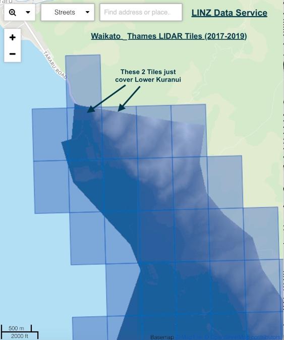
Figure A1.1. LIDAR tiles for Thames.
This LIDAR data gives elevations accurate to about 1m and it can be used to generate pseudo 3D topology as in Figure A1.2 and also contour maps, using a programme such as Q-GIS.
Thus, a contour map can be generated for the Kuranui Valley in the vicinity of the Shotover Claim.
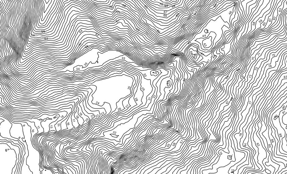
Figure A1.2. Contours in the Lower Kuranui Valley (metres).
The large flat area in the middle was originally a valley through which the Kuranui Stream flowed but a lot of mullock was pushed into it through the 1870s to the 1900s and it has since been filled in completely and a large shed built on it. The elevated flat area to the north is a building platform, first for the Thorburn house and recently, with extension, for a new house. The valley extends to the north east into what is almost a ravine, especially on the north side. It was here that the waterfall face extended right across the valley but this, and the valley beyond it has been extensively excavated, first by Hunt’s party, then the Kuranui Company and latterly by Hansen who took tens of thousands of tons out of the valley floor.
The Shotover Claim can be fairly accurately mapped onto this area. Figure A1.3 shows it superimposed on Google Earth. As one would expect, it straddles the valley and is centred on the waterfall area where the first gold was found. The one acre (0.4 hectare) freehold residence site is shown in green. It overlaps about 20% of the Shotover Claim but not the areas where most of the mining activity was carried out. T12/700 was mapped by Ritchie as the “Shotover Mine” but was an only approximate location.

Figure A.1.3. Shotover Claim and Main Buildings superimposed on Google Earth (The Kuranui Claim was to the NE, above the Shotover, and they sent ore down the northern side of the Shotover Claim, via Shutes and Rail, to the Kuranui Battery located near “314” Tararu Rd.
The contour and Google Earth maps can be superimposed and, although not completely clear (Figure A1.4), one can get some idea of how the Shotover Claim links to the contours.
The position of Stone’s shaft on the Kuranui Claim is probably wrong (no accurate mapping data was available) and it likely lies some 20 feet to the SE.

Figure A1.4. Combined Contour and Google Earth Map of Lower Kuranui.
The position of the Shotover Claim was fixed with reasonable accuracy by combining information from a Pullman map – Ref. 20 main article - (surprisingly accurate) and the Shotover map - Fig. 6 main article - (allowing for major errors in defining the shoreline, and bearings, possibly through confusing magnetic and true north readings). The position of the Shotover Shaft was able to be accurately pinpointed as it was part of an underground mining map which was very accurate. Stones shaft was not on this map, only on early surveys which had considerable errors in coordinates in the Kuranui region.
Mineral Resources created a composite map in 1982 by redrawing underground workings that had been mapped by mining surveyors. Their surveys were very accurate as demonstrated by the regular reports filed on the progress in tunneling north to meet the Shotover Shaft. They knew exactly how many feet they had to go, and the exact direction to reach the shaft, (Fig. A1.5).
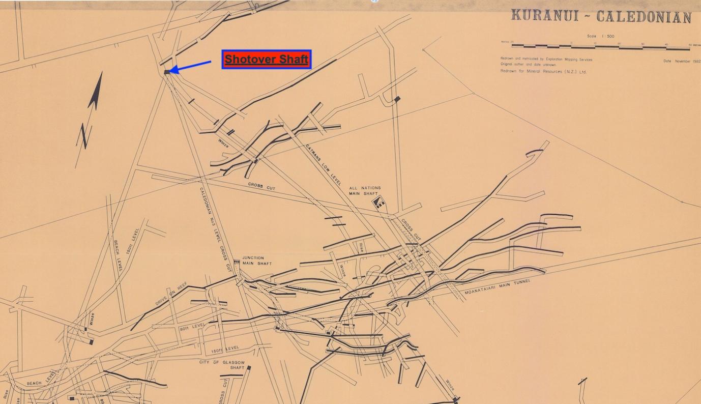
Figure A1.5. Part Mineral Resources map of the Kuranui-Caledonian region. The map extends south to the Big Pump and Caledonian Shafts, and as these are accurately mapped, the position of the Shotover shaft can be plotted.
The Shotover Shaft.
Special mention should be made of this shaft. At first, it was just a shallow bore from which water was pumped for the battery but over a period of about seven years it was deepened until, ultimately, it reached a depth of 260 feet below beach level and connected to the Caledonian No.3 level and hence to the Big Pump (extension of map in Figure A1.5).
From the time the Goldseeker battery was installed in July 1868, water was a problem. A partial solution was to sink a shallow bore. Initially, this went down about 70ft (the brace of the shaft was ~98 ft (30m) above sea level. Within a year, it had been dug to 130ft and a more efficient air pump installed.
Although the Shotover bonanza was almost entirely in the face of the waterfall, there was an expectation that if the path of the reef was followed straight down underground, rich ore might again be found. Thus, several drives were put in along the face of the reef at the 70 foot level in early 1870. The ore and mullock from these drives was taken up through the “Engine Shaft” which is presumably the same as the “Shotover Shaft”. Nothing of great note was discovered. By this time, Hunt et al had exited the Shotover Company. They had previously done some preliminary work on the reef underground which proved fruitless; thus, one suspects they planned an opportune exit.
Nevertheless, the Shotover Company carried on underground, ultimately extending the shaft to the 358ft level (260ft below sea level) and sending out exploratory drives from this level. In hindsight, one has to question their rationale for doing this, but they seemed to have a somewhat misplaced belief that somewhere, deep in the reef, payable gold would be found again. By August 1872 they were in trouble and the company wound up, but activity centred around the shaft was far from finished.
The shaft was seen as valuable for opening up ground for the Kuranui, All Nations and Long Drive companies. In the next five years there was much tunnelling activity and ultimately the Shotover Shaft was the northern “terminus” of a network, including the Caledonian No.3 level, which connected it with much of the central part of the Goldfield including the Big Pump. In addition, a deep level drive at 640ft was extended from the bottom of the Big Pump shaft to below the Shotover Shaft (Figure A1.5) but never connected with it, partly because of concerns about what would happen if they penetrated the Moanataiari slide. However, the main reason activity around the Shotover shaft ceased was simply that all these ventures proved uneconomic, so the shaft fell into disuse.
As discussed in the main article, Hansen spent several profitable years processing mainly surface stockwork from the area, but in mid 1895 sold out to a new Kuranui Company. The new owners did not heed the lessons of earlier miners and decided there had to be payable ore in the vicinity of the underground reef. (To be fair to them, this was also the opinion of a lot of mining commentators.) With this in mind, they repaired the shaft in December 1895, cleaning it out to 150ft and designing an ingenuous mining system in which ore and mullock from drives at the lower levels was raised 70ft to an underground chamber where was separated with ore being trucked along the level via the Kuranui tunnel directly to the battery down by the beach while the mullock was raised the additional 80ft to the surface. A horse whip powered the whole operation. This operation only carried on for a few years and the returns were modest. After that, the Shotover Shaft finally fell into disuse.
Thus, it can be seen that from a historical point of view, the shaft is an important part of the Shotover Claim story. Activity around it carried on for some 20 years after the Shotover Company folded and it is one of the few features on the claim that is still visible today. It illustrates well the optimism of miners who believed there were more riches to be found in the vicinity of the Shotover reef; they were wrong and as Fraser pointed out in 1910, payable gold in this area was only ever found down to 40 feet above sea level.
Finally, two questions arise about the Kuranui stream. The first is, what happened to the waterfall? Though there was never a major flow (quoted as being “2 sluice heads” which is ~50 litres of water a second) This would have given a distinct waterfall, and even a somewhat spectacular one in early August 1867 after the heavy rain. One of the first tasks on the Shotover Claim was to divert this water off the face of the reef. Obviously, once the whole reef and the valley behind it had been excavated, that was the end of the waterfall.
A more difficult question to answer is why the Kuranui stream today has completely dried up? Originally, the flow was sufficient above the Shotover Claim to provide water to the Homeward Bound battery and this, in turn, was recycled and could be used by the Shotover and Kuranui batteries in turn. Even at the top of a valley, there was a culvert across the stream, at least until the 1890s. Residences in the valley also got household water from the stream. And in heavy rain, “Rushes” caused a lot of damage on the Shotover site. I remember that there was still appreciable flow in the stream in the 1950s but now that has gone, so much so, that the Thames Coromandel District Council have allowed the new owners of 316 Tararu Rd to completely fill in the valley with no provision for stormwater clearance from further up the valley. Just where the water is going from the considerable catchment (see Figure A1.2) is a real mystery. Perhaps some is draining into old mine workings and the rest is progressively being absorbed by the rampant regrowth that has occurred since the 1940s (compare Figure A1.3 with the large areas of bare land in the 1944 aerial photograph in the main text).
Calculated Coordinates for Shotover Claim.
These have been derived from the Google Earth Map shown in Figure A3 and are probably accurate to better than + 5m. The exact coordinates of 316 can be read off TCDC Smart Maps (the Eastern most coordinate is very close to the original waterfall).
NZ Geodetic Datum 2000 NZTM
Appendix 2. William Alexander Hunt
Seeking reliable information on the life of William Hunt is frustrating and only can be gleaned by researching a lot of obscure material.
All sorts of stories, some wrong, some half true and others exaggerated abound. Even his full name is sometimes erroneously stated as “William Albert Hunt” which is a confusing variation on the name of an older brother, Albert William Hunt who had a controversial career as a gold prospector on the West Coast of the South Island in the early 1860s.
Brief Life Story.
William Hunt was born in Hokianga, in 1844 (some people state 1847 but his death certificate confirms the earlier date).
In 1927 his wife Jessie was interviewed and gave some insights into William Hunt’s early life. He was apprenticed as a boy “to engineering”, moved to Sydney when he was 18 and then to London where he worked for a “Well known engineering firm”. After spending some time on ships, he joined his brother Albert in Greymouth for a short time before moving back to Auckland.
Backtracking a little and consulting PapersPast it is possible to add some information for these early years. His parents Robert Hunt and Catherine Coonan, both born in Ireland, were married in 1840 in Hokianga. Robert had been married before. William Alexander was born in 1844 and Mary in 1851. The DOB of a second son, Albert William is not known. Robert Hunt moved to Auckland and established himself as a publican. Two court cases came to my attention. In the first, in 1855 in Auckland, a potential suitor of Elizabeth Hunt, a daughter from Robert’s first marriage, was found guilty of misrepresenting her age to the Registrar of Marriages. The second, in July 1859, related directly to William; his father complained that Tizard Engineers in Auckland were not properly instructing his son, as an apprentice, in the “Art and Mysteries” of Engineers’ fitter. Opinions proffered about William varied from “Willing to learn” to “he had been very subordinate lately”. In the end the case was dismissed, and it would seem that William must have finished an apprenticeship before leaving for Sydney at the end of his five years.
William’s next appearance in New Zealand newspapers was a brief item in the West Coast Times in September 1865, “If this should meet the eye of Albert Hunt, his brother William would gladly hear from him. Address to the office of this paper”. He obviously met his brother and they prospected at Bruce Bay because the next entry in the newspaper was the granting of a prospecting claim to them and two others in March 1866. However, this appeared to be another of Albert Hunt’s notorious hoaxes, and it was reported in the West Coast Times of the 12th of April 1866 that when the Warden arrived at Bruce Bay to sort things out William told him the, “he believed the rush to be a complete humbug.” Presumably, William fell out with his brother and that was when he moved back to Auckland.
So, summarizing all of this, it would appear that William had considerable experience in engineering (Auckland, Sydney, London, on ships) and must have gone straight to Greymouth when he returned to New Zealand in late 1865. There, he would have picked up the rudiments of prospecting for alluvial gold over the next few months, but certainly would have had no experience of hard rock mining. Moreover, it is extremely unlikely that he visited claims on the Shotover River. What he would have picked up at first hand is the extreme excitement and hype engendered by any hint of something resembling a gold rush.
I could find no information about his activities the next year in Auckland but, of course, from August 1867 to 1870 there are volumes of information on the activities surrounding the Shotover Claim. One odd event during this period is that his father Robert was adjudged bankrupt on the 1st of March 1869 with debts of £351. One would have thought William could have easily settled that amount. (Robert died in May 1874, aged 83, but the death notice made no mention of any family members; perhaps there had been a falling out.)
Finding out detailed information about Hunt in his post-Shotover days is difficult, partly because by mid-1870 he was resident in England, occupation “Marine Engineer”. Even his personal life before this is not well documented, though he set himself up as a gentleman in Auckland. Hunt had married Jessie Russell in September 1868. Years later, a descendant of Cobley somewhat derisively mentioned that Hunt had married a barmaid (Isdale 1967), but nothing could be further from the truth as, although Jessie was only 16, the Russell family was of some social standing in Auckland, she was by all accounts an attractive young woman and Hunt had become acquainted with the whole family. The family did run a boarding house and possibly this fact morphed into the “barmaid” comment. They had one daughter in 1869 before they moved to England in 1870 after he sold up in Thames (although he probably kept his Auckland home). Two sons were born in England, one while they resided in London, another in Surrey. They then returned to Remuera, Auckland and by 1876 two more children had been born. Again, they returned to England but then came back to Auckland in April 1881. (The Ancestry family tree of Price/Russell curated by Cindy Price is an invaluable source of information on Hunt’s family). Apart from census and birth records, I could not find any information about what he did in England.
By 1881 it would appear that Hunt had lost his fortune, not because of gross extravagance, as some would suggest, but according to his widow, through buying bogus American shares on the London Stock Exchange; no doubt taken for a ride by con artist individuals sensing he was young and naive when it came to handling a sudden fortune. Again, I have been unable to find information on the exact nature of his bad fortune, but it must exist in English financial records.
Exactly what he did in the next few years is also a bit vague, but children were born in Thames and Coromandel where he engaged in some mining. These ventures turned bad and by August 1883 he was adjudged bankrupt with assets of £150, liabilities of £633. Around this time, he did apply to the government for a £500 reward for discovering a goldfield, but this was rejected.
In 1885 he moved permanently to New South Wales where he eked out a living gold mining until his death in 1900 at the age of 56 from a stroke; interestingly, his occupation was then given as mechanical engineer. William’s mother Catherine moved to Australia to live with them and died in 1896; William was buried in the same plot. (Ironically, his sister Mary Chester, who died in 1902 is buried in the same plot as their father, Robert, in Devonport, NZ). William’s wife Jessie lived another 41 years, dying in 1941 aged 89. Again, in the early 1900s, she had applied to the New Zealand government for the £500 reward but, again, it was rejected. The bitter taste that this left was obvious when Mrs Hunt was interviewed in 1927 for an article that included a title, “Made a fortune and died penniless.”
The Shotover Claim
Several different versions have been given about how the bonanza was discovered in the Kuranui valley in early August 1867. However, the general consensus (certainly by George Clarkson himself!) is that it was Clarkson’s pick that unearthed the first gold in the waterfall. This debate about the actual discovery is really fairly minor and probably comes about because of certain resentment arising because the Shotover claim was commonly known, especially in the early days, as “Hunt’s Claim”; I will come to the reasons for this shortly.
Clarkson’s account some 40 years later in the Weekly Graphic and NZ Mail is probably as near to the truth as we are going to get. Essentially, it would seem Clarkson got a promising show of gold near the mouth of the Kuranui but did not have partners, so he teamed up with Hunt and John White and went back the next day when the bonanza was discovered. White played a key role as he was already on good terms with local Maori, spoke Maori himself and was able to help facilitate the delicate challenge of extending the limits of the goldfield beyond the middle of the Kuranui Stream. The addition of Cobley (a tailor by trade) as a partner gave the Shotover Four, a very effective team over the next three years.
During this time, it became clear that William Hunt was the driving force and the chief architect when it came to planning on how exactly to exploit their find. This was evident to everyone and almost certainly why the Shotover was often referred to as Hunt’s Claim - not because he sunk the first pick into gold. All this when he was scarcely 23! Of course, the others were not much older, Clarkson at 25, Cobley just 28 and White a comparatively oldie at 33. Hunt had two attributes that put the partners in good stead, first engineering experience and second, and coupled with this, good organisational skills. The extraordinary feature of the whole mining operation is that none of the four, bar Hunt, had any real mining experience and Hunt would have only picked up the most rudimentary skills of alluvial gold prospecting in his short soiree with his brother. Indeed, Matthew Barry had to demonstrate a simple test to prove there was gold in their ore.
Once they were organised on the claim, it appears that Hunt’s plan was to develop things in stages, all the time aware of security. They first processed rich ore on site which was smelted into gold bars by Richard Beck, a jeweler, in Auckland; this gave them a good income; they then used the Fraser and Tines battery set up at the mouth of the Kuranui in November 1867 for a few months until the Kuranui Claim took it over. After this, they reverted to processing ore on site, using a system of Berdans which gave good returns from the richest ore. All this is described in the main article, but it would appear that a major motivation for Hunt doing this would have been to ensure the security of the claim. We know that he had concerns over pilfering, eg. patrolling the site with a pistol and employing private detectives. Policing of the site itself was enough of a problem but shipping rich ore off the site to another battery would be a security nightmare. Possibly, this was also part of the reason for erecting a large accommodation building on the site as this minimised the opportunities for workers taking specimens with them off site after their shifts.
From late 1867, Hunt was planning for the erection of their own battery on the Shotover Claim. In the meantime, as well as keeping gold returns ticking over, they purposely stockpiled large amounts of moderately rich ore on site ready for processing in the Goldfinder once it arrived in July 1868. Even after the battery was erected, he was intent on making improvements which increased the efficiency of the plant. By mid-1869 they had essentially worked their way through all the profitable quartz on the claim, even sinking a shaft down the face of the reef just to be sure there was not more payable quartz. There was not.
At this stage they all exited the company, each with returns from gold sales plus the selling their shares totaling well over £40,000 and perhaps as high as £60,000. The exact amounts are unknown as some early Shotover gold returns are not recorded, added to which some gold sales bypassed official channels and were sold directly overseas for higher prices. As mentioned in the main article, it is probable that, all together, the Shotover four cleared over £200,000 by the time they sold up; a sum that would certainly be in excess of the net profit all operators obtained from the claim from actual returns on bullion mined. Of course, speculation by others in Shotover shares undoubtedly complicates the global financial picture even more.
Obviously, all of the Shotover Four had stuck together throughout this time with no major conflicts but it seems clear Hunt was the mastermind and hence the description “Hunt’s Claim’.
Fate of Fortunes.
It is well known that at least three of the Shotover Four did not hold on to their enormous fortunes for long. Basically, it would seem that while they had proved their ability to generate revenue from gold mining, none of them had a hard-nosed approach to business propositions in the larger world and were easily led into bad investments.
Only Clarkson was said to retain a reasonable fortune and pass it on to his family. But even he admitted to a number of huge financial losses - for example, £10,000 in one venture and £5,000 in another (Weekly Graphic 1909). Possibly, he also invested in his brother William’s gold mining venture in Wiseman’s Gully. But it would seem he was not telling the whole story as Julie Moor, who studied the extended Clarkson family in detail, researched George’s subsequent time in Australia and found that he too, ended up penniless before he returned to New Zealand a cripple (Treasury Journal). It would seem that White fared a little better but was in a poor financial state by the time he died. In summary, the Shotover Four all spiraled into financial disaster, only some took longer than others.
For all of them, it would seem that success as a hard-working gold miner did not stand one in good stead when it came to the perils of the investment world.
For reasons we outlined above, William Hunt was somewhat of a tall poppy, at least in Auckland and his financial woes hence got the most attention. Much is said about him having a “gilded” carriage built but I could not find evidence of this. He and Cobley certainly had imported some very fancy carriages and coaches from Melbourne in November 1868 and it is possible Hunt had some gilding added. And he did live a very luxurious life in Auckland, but it was his bad investments in London mentioned above that ruined him. In contrast, Cobley lost his money in New Zealand, first expending money on his grand development on the North Shore then suffering local investment disasters. And, as mentioned above, Clarkson and White did not fare much better. Nevertheless, it is Hunt who gets the main attention, not just because of his high profile from the Shotover days, but also a highly publicised court case involving Margaret Knox who took him to court for breach of promise to marry.
Court Case Knox vs Hunt.
This action for breach of promise to marry was heard in the Supreme Court in December 1868 and created immense public interest throughout New Zealand and beyond. The main reason was the huge amount, £5,000, claimed in damages. Many writers have since labelled Hunt in a poor light, as some kind of cad, but a careful reading of the extensive transcripts of the case reveal a somewhat more complex scenario.
There is no doubt, from the evidence presented to the court, that in late 1867 a serious relationship had commenced with Margaret Knox, a ring presented, marriage plans made, a future matrimonial home inspected etc etc. But then the wedding date of mid-March 1868 was put off and Hunt terminated the engagement in April. A few months later, in September, William Hunt married Jessie Russell and it was alluded to in court, that he had known her and the Russell family for some time.
The facts were fairly clear cut, and it was obvious that Miss Knox would be awarded damages but as it eventuated, £1300, nothing like the £5000 claimed, but still a tidy fortune.
Given all this, were there any redeeming facts in favour of Mr Hunt? A careful reading of the court transcripts suggests that there are quite a few. Chief amongst was the fact that Messer’s Hunt and Cobley, as incredibly rich young bachelors, were seen as “prime” catches in Auckland social circles. At least one matron had set herself up as a de facto matchmaker and arranged evenings with numbers of eligible young women in attendance. Coupled with this, even the acquaintances of the young gold miners were strongly suggesting it was time to marry and settle down and asking them which of the young ladies they preferred. And after Mr. Hunt “chose” Miss Knox, it was clear he had some doubts and did feel a little manipulated, for example, in agreeing to be photographed with Miss Knox who “coincidentally” turned up at Bartlett’s studio at the same time as Hunt in November 1867. Hunt was also under considerable stress in March 1868 when the engagement was broken off. He had planned a trip to Melbourne to finalise the purchase of the Shotover battery but had to deal with a vexatious legal ploy by Charles Mitchell to “jump” the claim.
It hardly needs stating that Hunt was very young, only 23, and probably found it difficult to cope with these constant pressures. Indeed, to me, the surprising revelation in the whole court case was the amount of time Hunt spent in Auckland rather than on the Shotover Claim. From the newspaper accounts of mining activities on the claim throughout this period, one would automatically assume that the four partners were camped there, except when travelling to Auckland on mining matters.
This was far from the case and, in fact, Hunt, and probably the others, spent a great deal of time in Auckland. Hunt regularly boarded at a Hotel (and later a house) and it would seem, only spent some of his time in Thames, being present for certain activities, e.g., a “crushing”. Presumably, one or other of the partners, or someone else they could trust, was on site at all times to supervise activities and the 30 plus men they employed and accommodated.
Possibly, affairs of the heart would have proceeded more slowly and in a more ordered manner if the Shotover Claim had been on a remote Goldfield and travel to a major city an occasional and arduous time-consuming activity. However, Thames was near unique amongst the world’s major goldfields in that it was an easy four-hour steamer trip to Auckland - and the perils of society.
We will never know the detailed motives of either Miss Knox in bringing the action nor of William Hunt in deciding to defend it, as neither appeared as witnesses. However, it would appear that either Miss Knox had been advised she had a good chance of getting a large sum of damages or that Hunt, either through a stubborn streak in his own character or ill advice, appeared not willing to reach some financial settlement out of court. Cobley on the other hand, who had been subject to the same matchmaking, apparently had made an escape from his and came to a financial arrangement with a Miss Smith. After the Hunt-Knox case, several newspapers alluded to the possibility, while skirting around libel laws, that perhaps the Smith family was thinking of revisiting the matter with the sum of £5000 again being mentioned. Apparently, nothing came of this.
Years later, in 1926, Neville Forder gave a somewhat tongue in cheek account of this sorry Hunt affair in which he pulls no punches and bluntly states that the matchmaker (“a faded beauty and the stylish wife of a butcher named Messenger”) had set up Miss Knox with William Hunt and later encouraged her to sue him for breach of promise. Perhaps a little exaggerated but close to the truth.
Unfortunately, the outcome of this whole sorry affair was that the court case and the claim of £5000 for breach of promise came in later years, along with his loss of a fortune, to define the public’s view of William Hunt, almost as much as his role in developing the Shotover Claim.
(Footnote. Miss Knox soon disappeared from public view and in October 1869 married William Adair. Mr Adair was originally from Ireland, and had worked in Australia for some years, before moving to Otago in 1866 to join the Goldrush, ironically prospecting on the Shotover River. Shortly after that he had the good sense to return to store keeping, then moved to Auckland. A few years after marrying Margaret they moved to Gisborne where he purchased the largest store in the town which, until 1873 had also served as a semi-official bank for the district. Possibly, the money awarded in the court case financed this purchase. Here, they enjoyed a prosperous and uneventful lifestyle, William dying in 1909 and Margaret in 1922. Gisborne was a very small town in the 1870s and Knox-Hunt court case may have remained somewhat under the radar. In any case, in those days, it would be something that the family would tend to keep quiet and certainly it would not be the kind of event that would feature in the family history, especially given that many of their descendants moved to England, far removed from any gossip in New Zealand.)
Photographs of William Hunt
Pursuing the old adage that “a picture is worth a thousand words” I sought out photographs of William Hunt. Again, this proved a frustrating exercise, and I did not find any high-quality images that I could state, with one hundred percent certainty, are of Hunt.
The most commonly reproduced image is one of the Shotover Four and, as far as I can ascertain, it comes from a picture that was once in the Thames School of Mines. Just where, when and who the photographer(s) was, if indeed all were taken at the same time is unknown. It is commonly stated that William Hunt is the one in the white coat on the middle left. Clockwise from above him are Cobley, White and Clarkson. Clearly, the person identified here as Hunt is somewhat older than early 20s.
Indeed, in her ebook The Shotover, Angela Curtis identifies the Shotover Four differently, moving the names 90 degrees clockwise. This would put Hunt at the top – and that is certainly a better likeness of him.

Figure A2.1 A montage of the Shotover Four
– in photographic language a Diamond Cameo.
The only other photo I have found in which Hunt is identified in a portrait, appeared in the Weekly
Graphic and New Zealand Mail of the 21st of July 1909 and it takes a bit of imagination to reconcile this likeness with the earlier photograph. Perhaps Hunt was a changed man after all the stress of his financial disasters.

Figure A2.2 “William Hunt” as identified in the
Weekly Graphic of 1909
Personally, in the absence of more compelling evidence, I have my doubts that either of the named people in these photos is Hunt.
Several early photographs taken on the Shotover Claim in 1867, are much more reliable but the images of individuals are blurry when blown up. The most reliable identification of Hunt was given by Fred Weston, editor of the 1927 Thames Diamond Jubilee Souvenir; he identified the four in a photo that was taken during the development of the claim.

Figure A2.3 Identification of the Shotover Four by Weston in 1927.
The likeness agrees with that identified with that given by Alistair Isdale (History of “The River Thames” 1967) in an earlier photo, which is also reproduced as Figure 5 in the main article. A blow-up from this photo gives a reasonable image of Hunt (Figure A2.4)

Figure A2.4 Crop of Hunt from Figure 5 -main article

Figure A2.5 Crop from Figure 7 in Main Article of the Shotover Four
Given Hunt’s distinctive bearded appearance (agreeing with the description in court records as bearded and whiskered) and also the ease of identifying the obviously diminutive dandy-like Cobley, it is reasonably easy to put names to the four in other photos, for example, this one taken by Bartlett late in 1867 (Figure A2.5).
The most valuable photograph if it still exists would be the carte de visite of Hunt with Miss Knox which was produced in court. No copies of this have been found, even though quite a few are likely to have been produced given that it was a hot item during the trial and Bartlett would have sold many copies. I set out to study uncatalogued photos by Bartlett that could potentially be the “missing” one. I used several criteria; first, it had to be produced in the late 1860s, second, it would be of an “unidentified couple” (Bartlett was a friend of Hunts and putting their names on such a photo would seriously strain their friendship – and be unnecessary anyway) and third, the male would be heavily bearded, in the clothes of a man going about town on business and the woman would not be in the finery that one would expect of someone from a well-to-do family going to an arranged sitting.
Indeed, there is one such item in the Auckland Libraries collection which fits the bill. It was taken by Bartlett in the 1860s (Bartlett still hand printed his name at that time), but nothing else is known about its provenance. The male could pass for the same person as in the photos above and the lady is dressed in what one would expect for someone of limited means working in a shop rather than the finery of someone from a well to do family. The expressions and stance of each gives the impression of some uneasiness. I leave the reader to judge whether the couple in this photograph could be Margaret Knox and William Hunt.

Figure A2.6 Possible Hunt-Knox carte de visite produced in the court case.
Additional References
“The Colours. The Search for Payable Gold on the West Coast from 1857 to 1864) Mark Pickering 2011. This gives a timeline of Albert Hunt’s exploits between 1863 and 1866. http://www.bestwalks.kiwi.nz/uploads/4/9/3/3/49336433/the_colours_new_design.pdf
“The Romance of the Thames”, New Zealand Graphic (aka The Weekly Graphic and NZ Mail), Vol.43, 21st July 1909
“The Shotover: 150 Year Souvenir” Angela Curtis, Available via Kindle or Paperback from Amazon.
“George Clarkson”, Judith Moore, The Treasury Journal, Vol.1 2008, thetreasury.org.nz
“Knox vs Hunt”, Several accounts of the court case and various sequels appeared in Auckland newspapers from December 1868 onwards. These are best accessed at Paperspast using the search term "knox hunt"~50.
“Shotover Hunt”, Neville Forder, Auckland Star Vol.62, 25th June 1926. Forder had quite a reputation for “unrestrained” journalism that sometimes sailed close to legal boundaries.

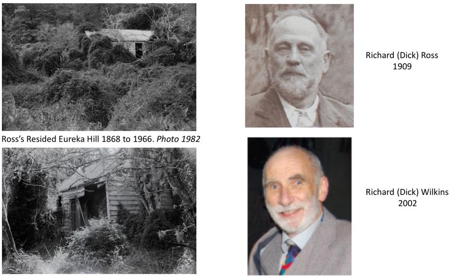
Comments
Post a Comment