1. Analysing the First Photographs of the Thames Goldfields
Richard (Dick) Wilkins
Introduction
When photographers came to Thames in the late 1860s, the bulk of their business was portraiture. Pictorial photography was not common, whether it be of street scenes around the town or, occasionally, of remote areas of the Goldfields, for the simple reason that it was not a financially attractive activity. The only real source of income from pictorial photography was selling postcards produced by contact printing; fortunately, many of these survive today and are of surprisingly good quality.
Taking photographs more than a few hundred metres from the studio involved the transport of bulky items including a darkroom, camera, tripod etc and photographic plates had to be prepared and developed on site.
In the first part of this article, I will discuss the cumbersome techniques using wet plate photography that were employed until almost the end of the 19th Century when dry photographic plates were introduced.
Despite these limitations, there were a handful of photographers who produced superb work in these early years. Unfortunately, the full potential of these images is not explored by most writers of books and articles on this period of Thames history, as they tend to use them to “decorate” their articles rather than to treat them, in their own right, as valuable sources of historical information.
Given this, it is perhaps an opportune time to analyse some of the more important photographs in detail.
As an example, we will look first at the work of early photographers of Grahamstown (aka Graham’s Town). This will introduce us to some of the major photographers, Bartlett, Mundy, Frith and McGarrigle. Unlike other locations, Grahamstown photographs are easy to identify and approximate dates are not in question; thus, the main analysis involves identifying buildings and the changes over time.
Part 2 will discuss Goldmining activity in the Tararu Creek area and Part 3 the Moanataiari valley, in particular, the tramway up to Punga Flat. Considerably more detective work is involved in analysing these images.
In a separate article, I will cover photography of the Shotover Claim in the Kuranui Valley, another popular haunt of early photographers.
Photography in the mid-19th Century.
Virtually all outdoor photography utilised glass plates coated with wet collodion. The camera was a relatively simple affair, easily constructed and essentially a box with a lens at one end which was racked in and out to focus the desired image on frosted glass at the other end, under which the photographic plate could be then inserted. No shutter was required as exposures were typically many seconds to a minute or more, so the photographer just took off the lens cap. Different focal length lenses could be fitted to the front, varying from wide-angle to telephoto.
Similar “field cameras” are still used by enthusiasts today. The author’s 4 x5” camera is shown in Figure 1; these days they are somewhat more refined and incorporate a shutter in the lens which enables exposures as short as 1/400sec with sensitive sheet film.

Figure 1: Mundy’s camera would be similar to the author’s modern “4 x 5 inch” Field Camera but twice as large, more solid and on a simple wooden tripod with few adjustments. Because exposures were many seconds, no shutter was required: the photographer simply removed the lens cap. The image on the ground glass screen is inverted, faint and only visible under a black dark cloth (it is enhanced here). After the set-up, a film holder is slid under the glass screen.
The field cameras used in the 1800s tended to be somewhat larger than 4 x 5” and, for instance, Daniel Mundy used an 8 x 10” camera for his 1870 Thames photographs. Other photographers had their own preferred size, and this preference can help to identify an “unknown photographer”, for example, Henry Frith used a ~4 x 7” format and Bartlett ~11 x 12.6”. All these cameras, together with a solid wooden tripod and a box of glass slides made for a heavy and fragile load, but that was only part of the challenge for the photographer.
The major challenge was preparing and developing the wet collodion plates on location.
In the dark, a clean glass plate was coated with a film of silver emulsion and, while still wet, exposed in the camera then, again in the dark, developed to give an image which was stabilised with a lacquer. If the plate dried out, it was ruined. Typically, the emulsion stayed wet for around 10 minutes, but Mundy used various tricks with damp cloths to extend this period to half an hour or more. To maximise this time window, the photographer would normally set up the camera on a vantage point, check the focus and the view (as in Figure 2) then go back to their dark tent, prepare the plates, scurry back to the camera, take the picture then quickly get back to the tent and develop the plate. (It was not until the 1880s that “dry plates” began supplanting this laborious process.)
As well as the camera, the photographer had to transport a lot of chemical solutions and developing vessels (fragile glass or heavy porcelain), a dark tent or cabinet, and had to be close to a source of clean water.
In a photographic studio, all the paraphernalia could be organised in a convenient manner but if the camera was set up more than a few hundred metres away from the studio, all the photography gear had to be transported to the location. If there were roads or bridle paths this could be done in a purpose-built cart, such as that used by Barker in Christchurch (Figure 2). Mundy had a bigger cart which he used around the South Island. Some intrepid photographers would carry everything short distances in a large back pack, but this was impractical over larger distances and when Mundy ventured into the back country he used a pack horse. Mundy stated that he could set up his dark tent and be ready to photograph in 45 minutes.
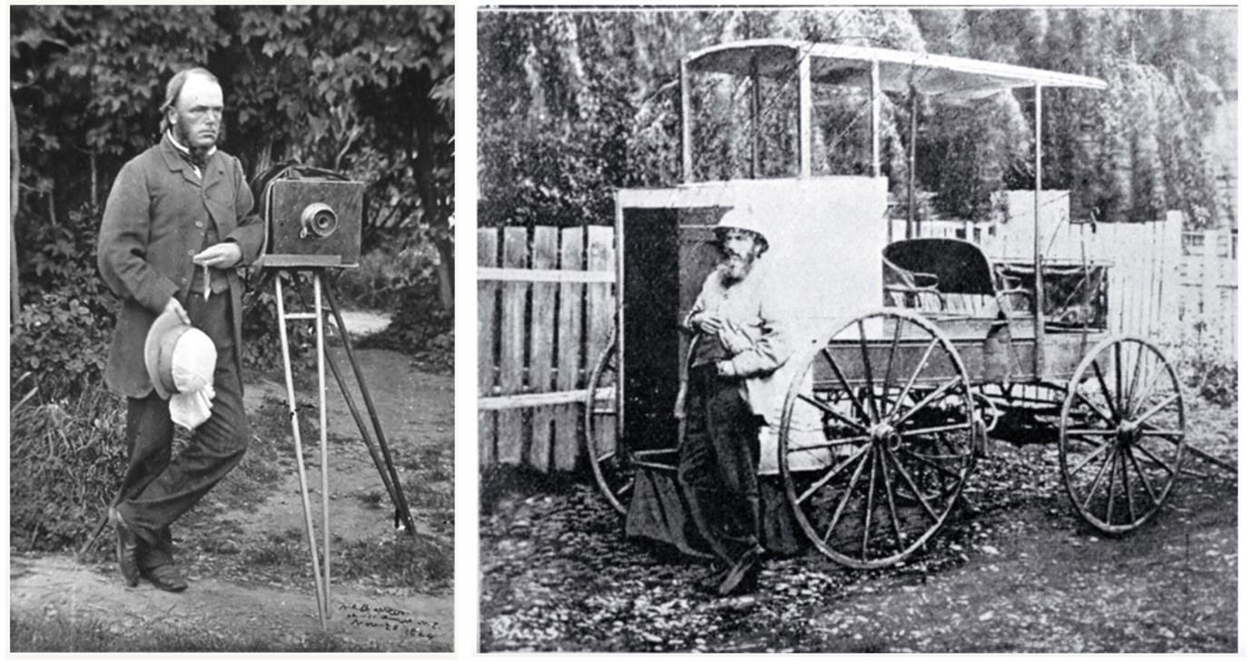
Figure 2: Dr Barker was a well-known amateur photographer in Christchurch. Shown with his camera in 1864 (left) and his portable darkroom ~1870 (right). From: Photography in New Zealand: A social and technical history, Frederic Hardwick-Knight: Dunedin: John McIndoe (1971). Photographers rarely photographed themselves, their cameras, or gave descriptions of their techniques.
Grahamstown
Early Thames photographs are fascinating, both for what they show and, in many cases, their artistic merit. Few of us, however, delve much deeper and extract the full information that these early cameras captured. Here I will show just how much information is waiting to be revealed, especially if we reference photographs to one another.

Figure 3: “Graham’s Town” Daniel Mundy (https://collections.tepapa.govt.nz/object/773481#open-iiifViewer)
The photograph I will use as an example is “Graham’s Town”, taken by Daniel Louis Mundy in early 1870. This has become an iconic image and, as well as contact prints being widely circulated, a 3-fold enlargement of 72 x 57cm was made by a carbon transfer process in London in 1875 to give exhibition prints of very high resolution, (one of the few surviving copies is in Te Papa, Figure 3). The photograph has also been converted into an engraving and even colourised using computation service offered by My Heritage; this colour rendition gives some interesting new insights, but the resolution appears to suffer and makes identification of some landmarks difficult (Thames NZ: Genealogy & History Resources, May 18th 2020 )
Before delving into the Grahamstown photographs, a little more background.
Why only a few Locations for Photographing Early Thames?
Once one is aware of the logistical challenges, one can understand why all the photographs taken on the early Thames Goldfield were from easily accessible locations on the flat or short distances up the valleys. For example, Bartlett travelled down from Auckland in mid-August 1867 and took some superb photographs as far north as the Kuranui Stream which he exhibited back in Auckland later in the month. Presumably, he used a cart or packhorse to transport his camera, chemicals and dark tent from the boat at Shortland. He made several later visits to Thames, photographing Hunts Claim and Grahamstown but there was not much money in landscape photography and his main source of income, as with other photographers, was portraiture.
(Interestingly, a photograph he took in his studio of Miss Knox with a supposedly reluctant William Hunt in December 1868 was important evidence in her Supreme Court claim of £5000 for breach of promise to marry. https://paperspast.natlib.govt.nz/newspapers/DSC18681218.2.39.1?end_date=31-12-1950&items_per_page=10&query=Bartlett+hunt&snippet=true&sort_by=byDA&start_date=01-01-1867&title=ALG%2cACNZC%2cAS%2cAKTIM%2cDSC%2cFRTIM%2cKWE%2cNZH%2cNZHAG%2cNZ%2cTO%2cPWT%2cROTWKG)
As substantial roads and bridle paths were constructed to service the mines, it became possible for photographers to access vantage points. Thus, we have a number of photographs taken above the town, from Irishtown, the hill where the War Memorial is now, and above Long Drive. Some were also taken up the Moanataiari Valley from both Messengers Hill and Eureka Flat. When Mundy visited Thames in March – May 1870 he took a series of photographs from the usual vantage points, but also several from less visited locations, namely areas around Tararu and Punga Flat. Some 24 of these were exhibited in Auckland in early June and most are available as high-resolution images on the Auckland Museum website. Thumbnails of these are shown in Figure 4.
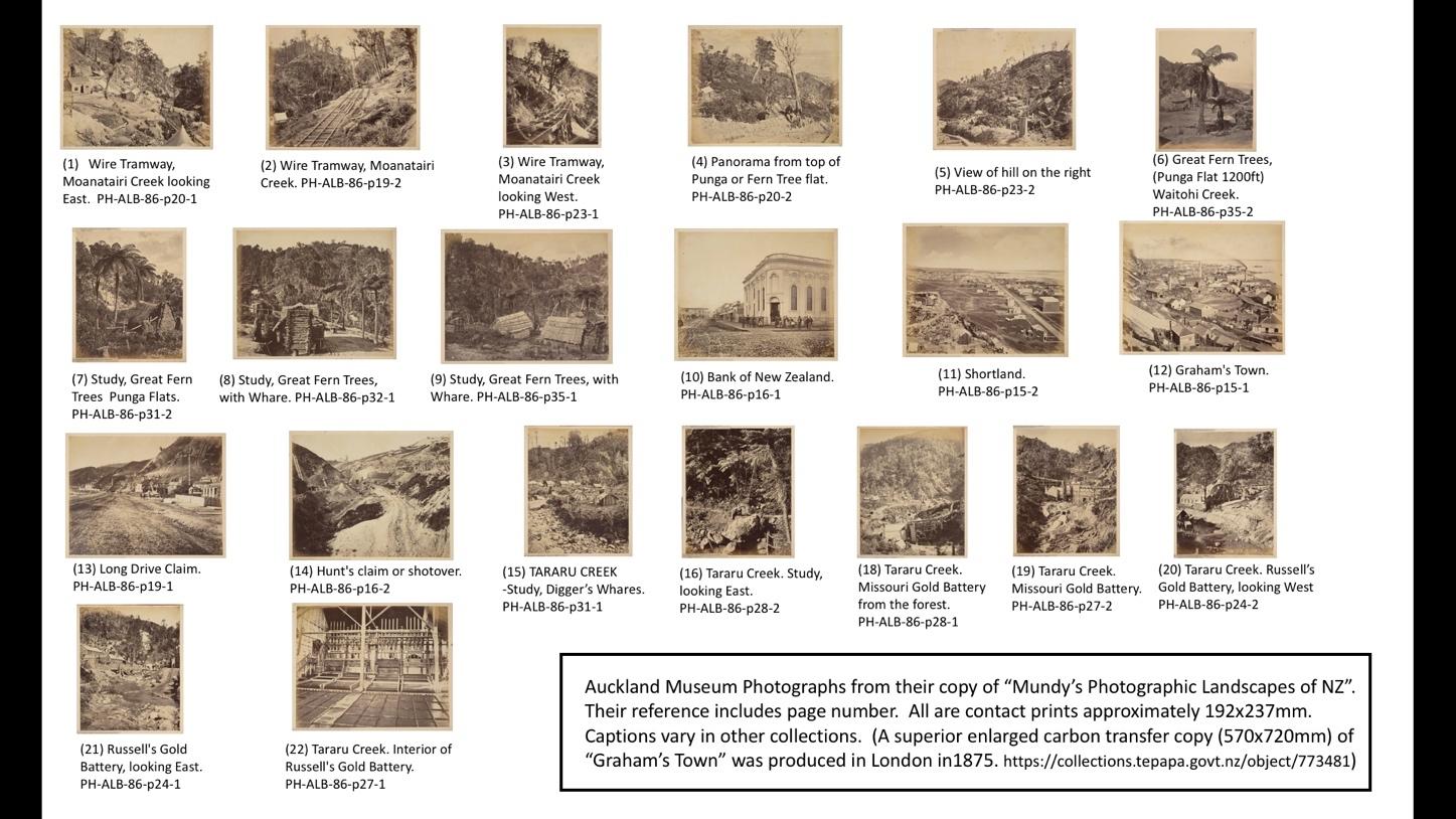
Figure 4: The Thames Goldfield prints Mundy exhibited in Auckland in June 1870.
That Photograph - Who, What, When?
Fortunately, for Mundy’s photographs, we know he was the photographer and exactly when he visited Thames. He sold up his business in Christchurch in February 1870 then travelled to the North Island, took the Thames photographs in April 1870, publicised the fact in the NZ Herald, and was sending views of the Thames Goldfields back to Christchurch in May and also exhibited 24 photos in Auckland in June 1870. Just for good measure he also wrote “Mundy” at the bottom of his negatives.
The provenance of many other Thames photographs is far more difficult to establish. Sometimes the photographer is unknown, the dates in various archives, if given, erroneous and, even what it purports to show can be wrong. More confusion can arise because some entrepreneurial photographers bought up stock that others no longer wanted (glass plates were heavy, bulky and fragile) from which they printed pictures for sale, often without proper attribution. One such person was James Richardson (1878-1942) who, as well as photographing in his own right, acquired some of the work of earlier photographers, often via copy negatives. Some newspapers, in turn, appeared to acquire some for their own archives, for example, The Thames Star. (Writers persist in attributing 1870s photographs to him, which is plainly impossible) Unfortunately, few early glass plates survive, and tonnes were recycled to recover the glass during the Great War.
All early photographs for sale were made by contact printing from the original glass plate onto photographic paper (Figure 5) by a process somewhat analogous to photocopying. Usually the light source was daylight and a frame used to define all or part of the glass plate. Sometimes the photographer would rephotograph the original image to give a different size, to produce a “positive” glass plate for a lantern slide, or to combine several photographs, or even to “photoshop” figures onto a street scene deemed too boring.

Figure 5: Schematic of Contact Printing (left) and an example of such a print mounted on the photographer’s card (right; Thames NZ: Genealogy & History Resources, January 9th, 2020). Hundreds of these might be produced and sold for a few pence each. This reproduction is of surprisingly high quality. Prints (minus card) could also appear in private photo albums without any identification. Such is the case for this photo; it appears with the two others in negatives the Alexander Turnbull Library prepared from a private Australian Photo Album. They were labelled “Photographer Unknown” but obviously taken by Henry Frith (see Figure 6).
Fortunately, as one gains experience, it is possible to make educated guesses about photographs. Each early photographer had their own style, different technical abilities, and often used characteristic plates sizes (archives usually give the dimensions of glass plates or the contact prints made therefrom, and early prints and postcards in private collections would all be contact prints). Mundy’s abilities were exceptional, all the way from preparing his chemicals to contact printing the final images. He used a top-quality lens and commented that he could pick out features 40 miles away. Others with similar technical abilities that we will mention below are Richard H. Bartlett, Henry Frith and John McGarrigle. The limitations that they all faced were coping with insensitive emulsions (around a thousand-fold slower than modern film), long exposures of the order of seconds to minutes, the need for sunny days with little or no wind, a requirement for a sturdy heavy tripod on a solid surface and the impossibility of photographing moving objects and people.
Photographing the inside of a building was challenging, but not impossible; obviously, photographing inside a mine was impossible.
Despite the problems, an enormous advantage of the large glass plates was that the contact prints showed far more detail than the same image compressed onto a small area of modern film (Figure 2). Moreover, a direct contact print was of sufficient size for most purposes and, because the negative emulsion was in direct contact with the paper emulsion, prints of exceptional quality could be produced.
Earliest Photographs of the Grahamstown Foreshore.
The earliest beachfront Grahamstown photographs were three taken by Henry Frith in late 1868 – early 1869. Frith photographed from the mudflats in front of the Kuranui Hotel, possibly from a structure. As stated above, these images are from copy negatives held by the Alexander Turnbull library. We only know they were taken by Firth because the middle one is identical to the card in Figure 5. The three photos are of remarkable quality given that they are simply copied from prints in the album. Frith took them all at the same time and it appears that he was attempting one of his favourite techniques, a panorama, but when we auto-stitch them together (Figure 6) we can see that he was only partially successful, possibly because his tripod did not have a swivel head to swing the camera. Anyway, here (and more so on the high-resolution images in the Alexander Turnbull website) we can clearly see, left to right, the Kuranui Valley, the Wakatipu bore, Kuranui Hotel, Goodall’s Battery (chimney at back), a half built Imperial Crown poppet, Melbourne Boarding House, Caledonia Chimney (behind hill in Moanataiari Valley), Prince Alfred Hotel (north side of Coromandel St). The chimneys of Perrys (just visible above the hotel) and Souter’s batteries are to the right. The site of the Thames Crushing Company Battery on the south side of Coromandel St is just out of sight. Take note of the track I have arrowed on the hill to the left above Long Drive. This was a favourite haunt of numerous photographers.
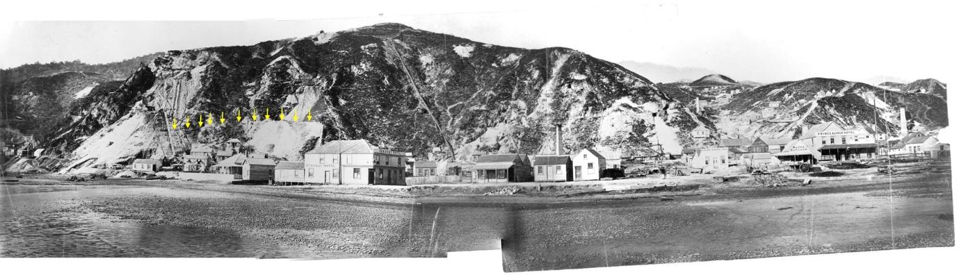
Figure 6: Attempt at Stitching Three 1868 Frith Photographs Together.
The three prints were, from left to right:
1. Kuranui Hotel and Kuranui Hill, special order, F- 65409-1/2, from Alexander Turnbull Library.
2. Kuranui Hotel https://ndhadeliver.natlib.govt.nz/delivery/DeliveryManagerServlet?dps_pid=IE200241&dps_custom_att_1=emu
3. Moanatairari Creek
https://ndhadeliver.natlib.govt.nz/delivery/DeliveryManagerServlet?dps_pid=IE195737&dps_custom_att_1=emu
Mundy’s “Graham’s Town”.
From Figure 6 it can be seen that setting up a camera anywhere along the length of this track would give good views of mining activities to the south (indeed in later years the same location also served photographers viewing, to the west, the Moanataiari and Kuranui-Caledonian batteries).
So, what exactly can we see in the Mundy photograph? I will concentrate on the mining ventures in the foreground. One can easily get things wrong, as the lens tends to compress features in the middle distance and the fact that early photographic emulsions were much more sensitive to the blue than the red end of the spectrum resulted in some features tending to overexpose and merge with those underexposed. Cross referencing to the earlier Frith photographs makes things easier, as does the knowing the date of the photo and thus the state of construction of the various wharves, the fact that the Tararu railway was yet to be built and the foreshore reclamation only extended south as far as the Thames Crushing Company battery which is on the south side of Coromandel St.
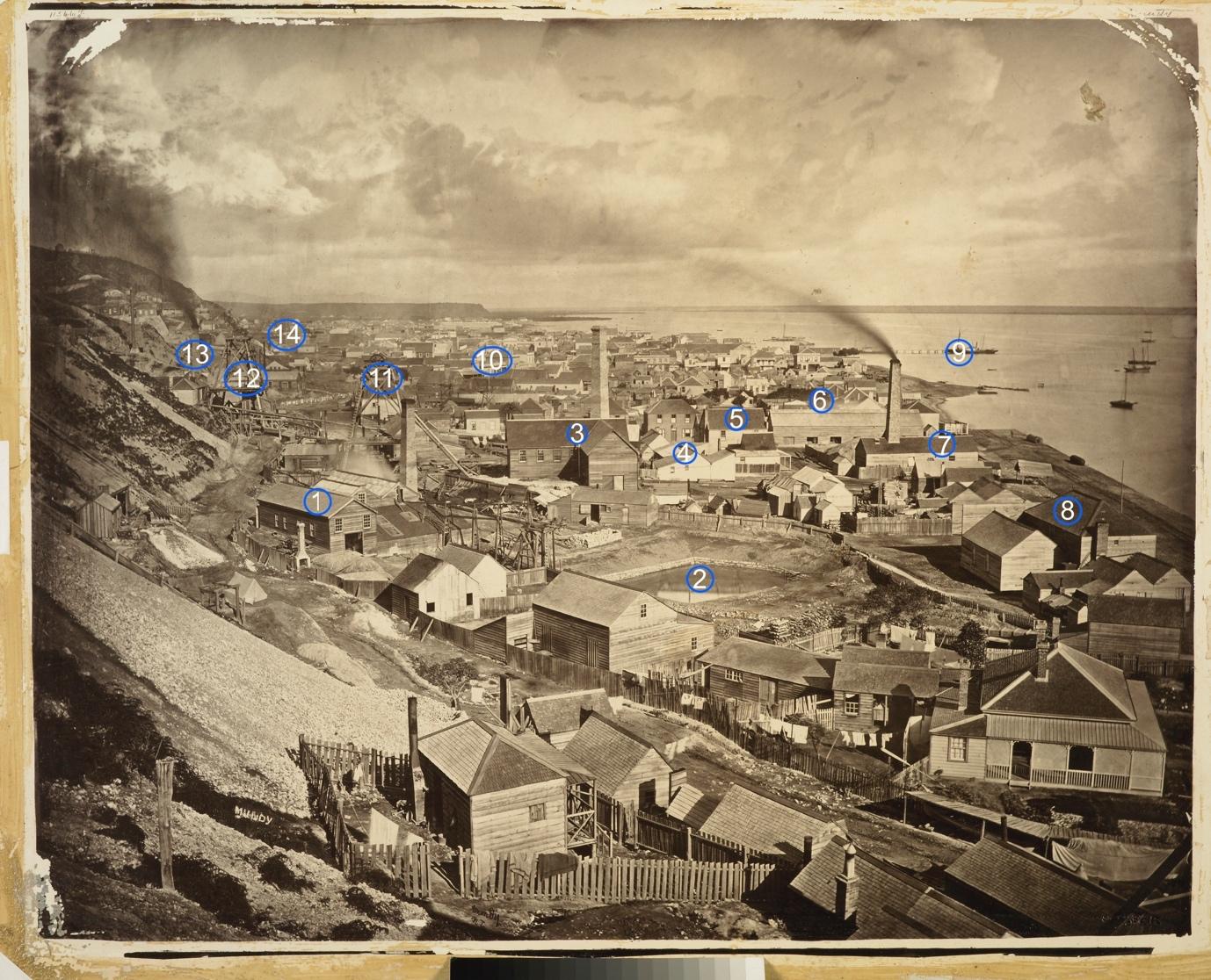
Figure 7: “Graham’s Town”, Daniel Mundy, Annotated.
Goodalls Battery (1), Saltwater Reservoir (2), Imperial Crown Boiler House (3), Melbourne Boarding House (4), Prince Alfred Hotel (5), Thames Crushing Company (6), Herald Battery (7), Kuranui Hotel (8), Goods Wharf (9), Governor Bowen Hotel (10), Imperial Crown Poppet Head (11), Tookeys (12), Perry’s Battery (13), Top of Souters Battery (14). Some names changed with new owners.
The major features are identified in the annotated copy of the Mundy photograph (Figure 7). Change obviously happened quickly on the Goldfield and in the year since the 1868 Frith photograph the Imperial Crown poppet head and its boiler house have been completed, the Herald Battery built and the construction of a salt water reservoir for the boiler houses well under way. The Prince Alfred Hotel (on the north side of Coromandel St) and the Melbourne Boarding house are now separated from the foreshore by the Herald Battery paddock.
Earlier Photographs from the Same Vantage Point
The challenges posed by the wet collodion process actually gives us a bit of serendipity as numerous photographers before and after Mundy, if only through necessity, also favoured the Long Drive location for viewing Grahamstown and, thus, we can follow the rise and fall of this area over time.
The earliest quality photograph that I found was taken by John McGarrigle (American Photographic Company, based in Auckland), probably in early 1868 somewhat to the south of Mundy, possibly using a more telephoto lens. The only industrial developments at that time are the original Goodall Battery (before extensions in late 1868) and the Thames Crushing Company Battery. Permanent buildings are relatively sparse, and tents still very much in evidence. The Melbourne Boarding house has yet to be extended, Coromandel St has few buildings and there are still houses on the reservoir site.

Figure 8: “General view from the Long Drive of Grahamstown and Shortland”, John McGarrigle (American Photographic Company). (https://collections.tepapa.govt.nz/object/830337#open-iiifViewer)
I recently discovered a somewhat later photo in the Nelson Museum collection (Figure 9) which is one of a number of copy negatives for which they have absolutely no information. However, a clue comes from others in their collection that have a very similar format, one of these was definitely taken by R.H.Bartlett. On this basis, I have attributed it to Bartlett. It was taken a few months before Mundy’s photo, as evidenced by the reservoir having just been excavated and the Herald Battery being still under construction (roof rafters just visible); also, the Imperial Crown poppet head appears to be not quite finished.
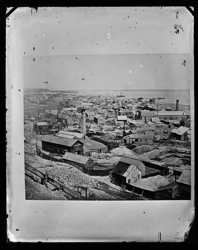
Figure 9: “Grahamstown”, R.J. Bartlett (?) https://collection.nelsonmuseum.co.nz/objects/P85974/thames
Later Photographs Taken of Grahamstown.
The rapid rate of change in this area can be gauged from the group of three photographs Frith took about 20 months after Mundy; the Grahamstown wharf has been extended (late 1870) but the Burke St wharf was yet to be started. This time Frith got a much better panorama (Figure 10). The salt water reservoir has been completed and there is now an elevated track running from the Imperial Crown to take mullock and tailings out to the mudflats, possibly as part of the Big Pump venture. The Prince Alfred Hotel and Melbourne Boarding House are now really hemmed in by industrial structures. Tracks of the Tararu railway are just visible near the foreshore and the structure in the water is possibly one of the Victoria boreholes.
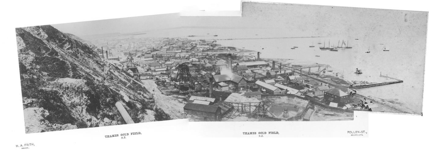
Figure 10: Three views over Grahamstown auto-stitched together: From “Snips and Snaps” pp.252-253, Noel Tozer: Edmund & Alexander: Sydney (2018).
Major changes continued in this area over subsequent years, notably with the Big Pump being built on the site of the Imperial Crown (https://thetreasury.org.nz/BigPump/pump.htm). Also, once the Burke St Wharf was constructed it provided a new favourite vantage point with Frith’s 1876 photograph one of many taken from the wharf that showed developments along the foreshore. (Figure 11). The Prince Alfred Hotel is now hemmed in by the Moanataiari flume, batteries, and heaps of mullock and tailings; to the north the Moanataiari and Kuranui-Caledonia batteries are operating; as with Frith’s early work, the print is of exceptional quality as evidenced by the houses on Eureka Hill being clearly visible.

Figure 11: “Kuranui Hill, Grahamstown” Henry Frith from “Snips and Snaps” p.248. A higher resolution copy (shown here) is available from the Hocken Library, Dunedin, P1990-015/49-335.
However, from the 1880s this area went into somewhat of a decline. The boom years were over, the growth of the township proper was largely south of Burke St, new big batteries were built to the north and much of the area became a semi-wasteland. This can be seen in Burton Brothers photographs taken in the 1880s (not shown here). This was particularly true of the land in the Imperial Crown lease between the Moanataiari and Waiotahi flumes although plants for the ill-fated La Monte and Newbery–Vautin processes were built here in the 1880s and 1890s (https://thetreasury.org.nz/lamonte/wilkins.htm).
Two photographs, taken at the end of the century show just how little remained 30 years after Mundy took his photograph. The Foy Brothers print of 1898 shows that while the Big Pump is still there, along with the May Queen Extended Battery (Figure 12), the area is getting a bit desolate. In just a few more years, when William Price photographed the same scene around 1900 most of the area is clear of industrial buildings and only the remains of the Big Pump are left (Figure 13); the big building against the hills on the left is the “New” Waiotahi Battery which only operated for a few years.
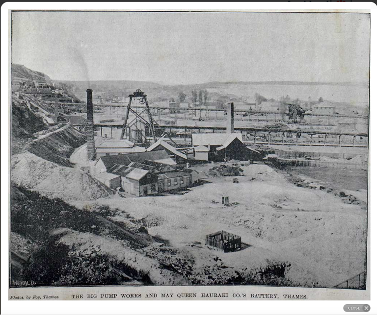
Figure 12: “The Big Pump Works and May Queen Hauraki Co.s Battery”, Foy Bros, from the Auckland Weekly News, 30th July 1898.
http://www.aucklandcity.govt.nz/dbtw-wpd/exec/dbtwpub.dll?BU=http%3A%2F%2Fwww.aucklandcity.govt.nz%2Fdbtw-wpd%2FHeritageImages%2Findex.htm&AC=QBE_QUERY&TN=heritageimages&QF0=ID&NP=2&RF=HIORecordSearch&MR=5&QI0=%3D%22AWNS-18980730-2-2%22

Figure 13: “General View of Thames Looking South” ca. 1900, William Price
https://natlib.govt.nz/records/23240326
The Thames Borough Council realised this was a problem area and increasingly controlled the deposition of tailings and, although reduction of the gigantic heaps was achieved via dredging, re-extraction and reclamation of mudflats, this whole area remained fairly unattractive right until the 1940s as can be gauged from aerial photographs (Figure 14). The subsequent Moanataiari reclamation finally dealt to the tailings and mullock, but this was not without its own environmental problems.

Figure 14: Portion of an aerial photograph taken in 1944 with “waste” areas ringed.
Conclusions.
By starting with just one photograph, such as Mundy’s “Graham’s Town” and sourcing other photographs taken of the same area over a period of time, we can build up a very good picture of the rise and fall, and changes in this historical area of Thames over thirty years.
In the accompanying articles, I will look first at developments in the Tararu Valley (Part II) and then at the Moanataiari Valley (PtIII); in this last example, I will concentrate on a set of Mundy’s photographs he took of the Moanataiari Tramway. In addition, early maps, 20th Century aerial photographs, newspaper accounts and Google Earth will be used to supplement the superb visual information in Mundy’s work to reveal, for the first time, an accurate picture of the upper sections of this tramway.
Notes.
1. The reader is encouraged to view the photographs on the referenced websites in higher magnification to appreciate the full detail that these large cameras could capture. When this is done (for example, Figure 14), it is possible to detect subtle features, such as the chimney of the Thames Crushing Company which is almost hidden behind the chimney of the Herald Battery in Figure 1.

Figure 14: Two chimneys not one.
2. In 1874, Mundy wrote a description of his photographic techniques, a facsimile of which is reproduced in https://www.tepapa.govt.nz/sites/default/files/tuhinga.20.2009.pt6_.p67-80.mitchell_0.pdf.

Dick - like your new blog with an interesting academic slant on heritage of Thames along .with the analysis of the early phoographers and their photographs. eg Daniel Mundy. Have you also considered the early Thames photos of Daniel Beere in 1868 who also was a Mining Surveyor, Land surveyor and railway engineer and surveyor. Also Henry AKA Harry Gorrie an amateur photographer who had access to those early chemical used and took photos of those early years of the Thames Goldfield before he was tranferred to the new West coast gold fields as a gold buyer. Thank you for putting up your new blog and look forward to you future vignettes.
ReplyDelete